IMAGES TAKEN NEAR TO
Victoria Way, WOKING, GU21 8EW
Introduction
This page details the photographs taken nearby to Victoria Way, GU21 8EW by members of the Geograph project.
The Geograph project started in 2005 with the aim of publishing, organising and preserving representative images for every square kilometre of Great Britain, Ireland and the Isle of Man.

There are currently over 7.5m images from over14,400 individuals and you can help contribute to the project by visiting https://www.geograph.org.uk
Image Map
Images are licensed for reuse under creativecommons.org/licenses/by-sa/2.0
Notes
- Clicking on the map will re-center to the selected point.
- The higher the marker number, the further away the image location is from the centre of the postcode.
Image Listing (300 Images Found)
Images are licensed for reuse under creativecommons.org/licenses/by-sa/2.0
Image
Details
Distance
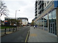
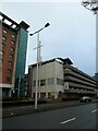
1
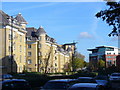
Victoria Way
Arterial dual-carriageway road cutting across the northern edge of Woking town centre. These flats were built ca 2005.
Image: © Colin Smith
Taken: 2 Nov 2007
0.03 miles
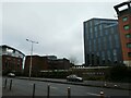
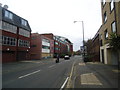
3
Approaching the junction of Victoria Way and Waterside
Image: © Basher Eyre
Taken: 30 Dec 2021
0.04 miles
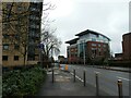
4
Looking from Victoria Way into Waterside
Image: © Basher Eyre
Taken: 30 Dec 2021
0.04 miles
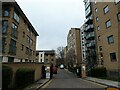
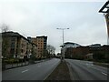
7
Victoria Way Flats
New 21st Century development in Woking, wedged between Victoria Way and the Basingstoke Canal (behind these apartments).
Image: © Colin Smith
Taken: 2 Nov 2007
0.06 miles
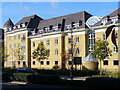
9
Looking across Victoria Way towards the HG Wells Conference Centre
Image: © Basher Eyre
Taken: 30 Dec 2021
0.06 miles
