IMAGES TAKEN NEAR TO
Church Street West, GU21 6BQ
Introduction
This page details the photographs taken nearby to Church Street West, GU21 6BQ by members of the Geograph project.
The Geograph project started in 2005 with the aim of publishing, organising and preserving representative images for every square kilometre of Great Britain, Ireland and the Isle of Man.

There are currently over 7.5m images from over14,400 individuals and you can help contribute to the project by visiting https://www.geograph.org.uk
Image Map
Images are licensed for reuse under creativecommons.org/licenses/by-sa/2.0
Notes
- Clicking on the map will re-center to the selected point.
- The higher the marker number, the further away the image location is from the centre of the postcode.
Image Listing (360 Images Found)
Images are licensed for reuse under creativecommons.org/licenses/by-sa/2.0
Image
Details
Distance
1
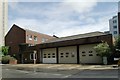
Woking Fire Station
Woking Fire Station, Church Street West, Woking, Surrey
Image: © Kevin Hale
Taken: 7 May 2007
0.02 miles
2
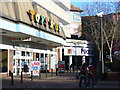
Toys 'R' Us, Woking
Large toy store at one of the entrances to the Peacocks Shopping Centre.
www.woking.gov.uk
Image: © Colin Smith
Taken: 7 Dec 2011
0.02 miles
3
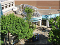
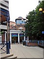
Wolsey Place entrance, Woking
Looking down on the entrance to the Wolsey Place shopping mall from the Toys-R-Us car park.
Image: © Alan Hunt
Taken: 16 May 2015
0.02 miles
4
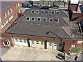
Woking fire station
The fire station in Cawsey Way from the Toys-R-Us car park. This building is due for re-development in the near future.
Image: © Alan Hunt
Taken: 16 May 2015
0.02 miles
5

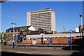
Towards Woking
A distant view of the towers of Victoria Square in central Woking, viewed over the western outskirts of Guildford from the Hog's Back.
Image: © Ian Capper
Taken: 23 Jun 2021
0.04 miles
6
Cawsey Way, Woking
Looking along Cawsey Way from the Toys-R-Us car park with Wolsey Place shopping mall off to the left.
Image: © Alan Hunt
Taken: 16 May 2015
0.04 miles
7
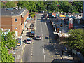
Woking townscape
The view south from the Toys-R-Us car park with the training tower of the firestation in the foreground with Guildford Road beyond. Much of this area has been designated for a major re-development including the firestation.
Image: © Alan Hunt
Taken: 16 May 2015
0.04 miles
8
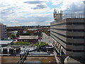
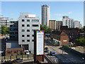
Woking skyline
Looking west from the top level of the main town centre multi-storey car park. In the foreground is the roof of the Wolsey Place shopping centre, The curved balustrade to the right marks the entrance to the Peacock centre. The flat roof with the glass parapet on the left is the facade of Export House, The large office block that can be seen from miles around. On the right is the "Toys-R-Us" car park, the store is on the bottom level. The detached building in the middle distance is the fire station with Church Road West the prominent road on the right.
Image: © Alan Hunt
Taken: 29 Jun 2011
0.05 miles