IMAGES TAKEN NEAR TO
Goldsworth Park Trading Estate, Kestrel Way, WOKING, GU21 3BA
Introduction
This page details the photographs taken nearby to Goldsworth Park Trading Estate, Kestrel Way, GU21 3BA by members of the Geograph project.
The Geograph project started in 2005 with the aim of publishing, organising and preserving representative images for every square kilometre of Great Britain, Ireland and the Isle of Man.

There are currently over 7.5m images from over14,400 individuals and you can help contribute to the project by visiting https://www.geograph.org.uk
Image Map
Images are licensed for reuse under creativecommons.org/licenses/by-sa/2.0
Notes
- Clicking on the map will re-center to the selected point.
- The higher the marker number, the further away the image location is from the centre of the postcode.
Image Listing (31 Images Found)
Images are licensed for reuse under creativecommons.org/licenses/by-sa/2.0
Image
Details
Distance
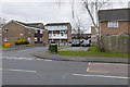
1
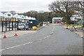
Kestrel Way, Horsell
Kestrel Way in the Goldsworth Park Trading Estate.
Image: © Alan Hunt
Taken: 19 Mar 2016
0.05 miles
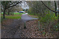
2
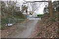
Walkway to Sythwood
The walkway between Sythwood in Goldsworth Park and Kestrel Way in the trading estate
Image: © Alan Hunt
Taken: 19 Mar 2016
0.09 miles
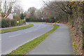
3
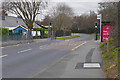
Sythwood, Goldsworth Park
One of the main feeder roads in the Goldsworth Park estate. Sythwood school is off to the left by the crossing point.
Image: © Alan Hunt
Taken: 19 Mar 2016
0.09 miles
4
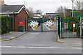
Sythwood School, Goldsworth Park
The gates of Sythwood Primary School on Sythwood, one of the main feeder roads in Goldsworth park.
Image: © Alan Hunt
Taken: 19 Mar 2016
0.10 miles
5
Brookfield, Goldsworth Park
Brookfield off Sythwood in Goldsworth Park, a large housing estate to the west of Woking.
Image: © Alan Hunt
Taken: 19 Mar 2016
0.11 miles
6
Horsell Birch
The footpath across Horsell Birch approaching the water pumping station access road off the High Street.
Image: © Alan Hunt
Taken: 12 Dec 2015
0.14 miles
7
Sythwood, Goldsworth Park
One of the feeder roads in the Goldsworth Park housing estate.
Image: © Alan Hunt
Taken: 19 Mar 2016
0.14 miles
8
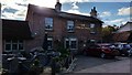
The Cricketers, Horsell
The oldest part of the present building is said to date from the 16th century and is timber-framed, although it was later encased in brick. This probably happened sometime during the 18th century when the newer, front part of the building was added.During its long history, the building has been used variously as a general store, a poor house, a school and the village lock-up before becoming and remaining a pub. http://www.baronspubs.com/cricketers/about/
Image: © Richard Rogerson
Taken: 6 Nov 2016
0.15 miles
9
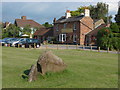
The Cricketers, Horsell
The Cricketers from the green. There is a large block of sandstone in the foreground, typical of the type that is associated with the Bagshot Beds.
Image: © Alan Hunt
Taken: 2 Jul 2011
0.16 miles
10
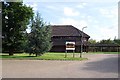
Goldwater Lodge
This building is Goldwater Lodge - specifically the part occupied by Toad Hall Nursery. The Community Hall is on the other side.
Image: © Ron Strutt
Taken: 29 Aug 2005
0.16 miles