IMAGES TAKEN NEAR TO
Chobham Road, WOKING, GU21 2JB
Introduction
This page details the photographs taken nearby to Chobham Road, GU21 2JB by members of the Geograph project.
The Geograph project started in 2005 with the aim of publishing, organising and preserving representative images for every square kilometre of Great Britain, Ireland and the Isle of Man.

There are currently over 7.5m images from over14,400 individuals and you can help contribute to the project by visiting https://www.geograph.org.uk
Image Map
Images are licensed for reuse under creativecommons.org/licenses/by-sa/2.0
Notes
- Clicking on the map will re-center to the selected point.
- The higher the marker number, the further away the image location is from the centre of the postcode.
Image Listing (36 Images Found)
Images are licensed for reuse under creativecommons.org/licenses/by-sa/2.0
Image
Details
Distance
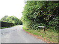
2
Barley Mow Lane, Knaphill
The narrow road that runs from Anchor Hill to the Chobham Road. It is named after the former Barley Mow Inn, now a private house, that was situated by the junction with Chobham Road.
Image: © Alan Hunt
Taken: 26 Sep 2012
0.05 miles
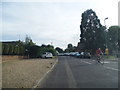
3
Chobham Road at the corner of Barley Mow Lane
Image: © David Howard
Taken: 1 Sep 2013
0.05 miles
4
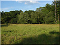
Waterers Park
The meadow area of Waterers Park. These old meadows were saved from development some years ago when the local villagers raised funds to enable the Woodland Trust to purchase the area of woods and meadows next to the Waterers Park recreation ground.
Image: © Alan Hunt
Taken: 27 Jun 2010
0.06 miles
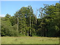
5
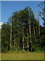
Waterers Park
A stand of beech trees by the meadow area of Waterers Park, A small Woodland Trust reserve next to the recreation ground.
Image: © Alan Hunt
Taken: 27 Jun 2010
0.06 miles
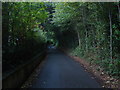
6
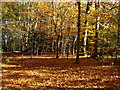
Barley Mow Woods
A sunny autumn morning showing this small Woodland Trust property at its best.
Image: © Alan Hunt
Taken: 11 Nov 2012
0.11 miles
7
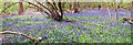
Bluebell Wood
A carpet of bluebells. For more pictures refer to picture Image
Image: © Len Williams
Taken: 1 May 2015
0.11 miles
8
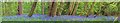
Bluebell Carpet
A carpet of bluebells. For more pictures refer to picture Image
Image: © Len Williams
Taken: 1 May 2015
0.11 miles
9
Waterers Park
Trees on the edge of the meadow area next to Barrs Lane.
Image: © Alan Hunt
Taken: 2 Jul 2011
0.11 miles
10
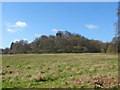
The scarp, Knaphill
The hill (the name escapes me at present) near the Priory Hospital which forms part of the scarp that runs through Knaphill
Image: © Alan Hunt
Taken: 23 Apr 2013
0.12 miles