IMAGES TAKEN NEAR TO
Bluebell Rise, LIGHTWATER, GU18 5YN
Introduction
This page details the photographs taken nearby to Bluebell Rise, GU18 5YN by members of the Geograph project.
The Geograph project started in 2005 with the aim of publishing, organising and preserving representative images for every square kilometre of Great Britain, Ireland and the Isle of Man.

There are currently over 7.5m images from over14,400 individuals and you can help contribute to the project by visiting https://www.geograph.org.uk
Image Map
Images are licensed for reuse under creativecommons.org/licenses/by-sa/2.0
Notes
- Clicking on the map will re-center to the selected point.
- The higher the marker number, the further away the image location is from the centre of the postcode.
Image Listing (21 Images Found)
Images are licensed for reuse under creativecommons.org/licenses/by-sa/2.0
Image
Details
Distance
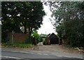
1
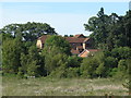
Lightwater housing
Modern housing in the large estates on the north of the Red Road with the MOD ranges in the foreground.
Image: © Alan Hunt
Taken: 30 Jun 2013
0.06 miles
2
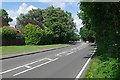
The Red Road, Lightwater
Looking east along the Red Road with the housing estates of Lightwater behind the trees on the left.
Image: © Alan Hunt
Taken: 15 Jun 2016
0.07 miles
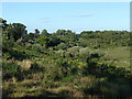
3
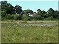
The Folly Bog
The Folly Bog just north of the Pirbright Range Fence is managed by the use of sluices and dams to maintain an ecologically important area of wet heathland. In the background are the housing estates north of the Red Road.
Image: © Alan Hunt
Taken: 30 Jun 2013
0.11 miles
4
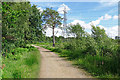
Military track, Pirbright Ranges
An access track near the Red Road north of the Range Danger Area.
Image: © Alan Hunt
Taken: 15 Jun 2016
0.16 miles
6
The Folly
View towards the area known as The Folly which gives its name to the Folly Bog.
Image: © Alan Hunt
Taken: 18 Jul 2010
0.17 miles
7
The Folly Bog, Pirbright Ranges
The Folly Bog north of the range fence near West End. This area has sluices in place to reduce drainage and keep the bog wet.
Image: © Alan Hunt
Taken: 15 Jun 2016
0.17 miles
8
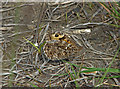
Grayling, Folly Bog
A Grayling (Hipparchia semele) in the Folly Bog near West End. This is one of the best camouflaged butterflies in the UK, when settled on gravel or pine detritus it can totally disappear. The eye on the forewing is normally hidden but the butterfly will flick up the forewing when it feels threatened to distract predators. The heaths of southern England are among its last strongholds, the species having suffered major population declines over the last 20 years.
Image: © Alan Hunt
Taken: 31 Jul 2014
0.17 miles
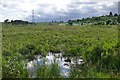
9
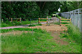
Folly Bog
Folly Bog is an area that lies between the northern edge of the Pirbright Ranges danger area and Red Road. Although owned by the MOD it is cared for by the Surrey Wildlife Trust. As an experiment and in order to help the boggy conditions to revive, the Trust has brought in a herd of Highland cattle to keep the invasive scrub under control. So far, according to the rangers, the experiment seems to be working well, tender birch shoots seeming to be very much to the cattle's liking. In order to prevent the cattle wandering it has been necessary to install fencing and cattle grids.
Image: © Ron Strutt
Taken: 30 Sep 2005
0.18 miles
10
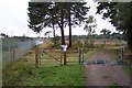
Folly Bog access gates
The access gate and cattle grid on the road to the Folly Bog north of the Pirbright Range Danger Area, the fence of which is on the right.
Image: © Alan Hunt
Taken: 15 Jun 2016
0.19 miles