IMAGES TAKEN NEAR TO
Theobalds Way, CAMBERLEY, GU16 9RF
Introduction
This page details the photographs taken nearby to Theobalds Way, GU16 9RF by members of the Geograph project.
The Geograph project started in 2005 with the aim of publishing, organising and preserving representative images for every square kilometre of Great Britain, Ireland and the Isle of Man.

There are currently over 7.5m images from over14,400 individuals and you can help contribute to the project by visiting https://www.geograph.org.uk
Image Map
Images are licensed for reuse under creativecommons.org/licenses/by-sa/2.0
Notes
- Clicking on the map will re-center to the selected point.
- The higher the marker number, the further away the image location is from the centre of the postcode.
Image Listing (10 Images Found)
Images are licensed for reuse under creativecommons.org/licenses/by-sa/2.0
Image
Details
Distance
1
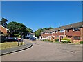
Navigating northwards up the Basher (26)
Houses in Coniston Close
Image: © Basher Eyre
Taken: 5 Jun 2023
0.09 miles
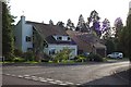
2
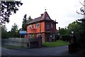
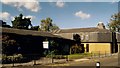
Ridgewood Centre
The picture shows the lodge of the Ridgewood Centre, a unit run by the Surrey and Borders Partnership NHS Trust, a specialist NHS Trust providing the mental health, including drug and alcohol services, child and adolescent mental health and specialist learning disabilities services to the people of Surrey, Croydon and north east Hampshire. The site provides residential mental health care for the area.
Image: © Ron Strutt
Taken: 29 Sep 2005
0.21 miles
5
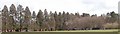
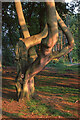
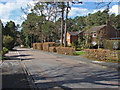
Wellingtonia Pine, avenue 2
An avenue of Wellingtonia pines stretched from the Upper Chobham Road to Brookwood House, (now the Ridgewood Centre). This photo shows the avenue as seen from the corner of Cumberland Road and Martindale Avenue. For a view from within the avenue refer to picture Image
Image: © Len Williams
Taken: 30 Mar 2008
0.23 miles
6
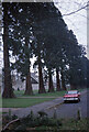
Trees in Yockley Close
I believe these trees are called Wellingtonia.
Image: © Peter Shimmon
Taken: 1 Jan 1977
0.23 miles
7
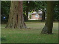
Heatherside Recreation Ground
The edge of the park with the houses on Yockley Drive in the background.
Image: © Alan Hunt
Taken: 14 Aug 2011
0.23 miles
9
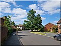
Goldney Road, Camberley
A residential road in the Heatherside estate in Camberley. Most of this area was developed in the 1970s.
Image: © Alan Hunt
Taken: 19 Apr 2013
0.24 miles
10
Chobham Ridges suburbia
Quite why it's called Chobham Ridges isn't clear - it's several miles from Chobham - but it's a very desirable spot to live, not least because there's no chance of development on the other side of the main road (ie behind the photographer). The irony is that a hundred years or so ago, the land was worthless. Nowadays even a small house costs a fortune. This is Redwood Drive looking west across the B3015.
Image: © Ron Strutt
Taken: 29 Sep 2005
0.25 miles