IMAGES TAKEN NEAR TO
Bicknell Road, CAMBERLEY, GU16 8SZ
Introduction
This page details the photographs taken nearby to Bicknell Road, GU16 8SZ by members of the Geograph project.
The Geograph project started in 2005 with the aim of publishing, organising and preserving representative images for every square kilometre of Great Britain, Ireland and the Isle of Man.

There are currently over 7.5m images from over14,400 individuals and you can help contribute to the project by visiting https://www.geograph.org.uk
Image Map
Images are licensed for reuse under creativecommons.org/licenses/by-sa/2.0
Notes
- Clicking on the map will re-center to the selected point.
- The higher the marker number, the further away the image location is from the centre of the postcode.
Image Listing (30 Images Found)
Images are licensed for reuse under creativecommons.org/licenses/by-sa/2.0
Image
Details
Distance
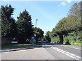
1
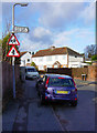
Bicknell Road
Photograph looking up Bicknell Road from the junction with Farm Road in low December sunshine. (I obscured the registration plate of the car out of respect for the owner's privacy).
Image: © Euchiasmus
Taken: 3 Dec 2007
0.04 miles
2
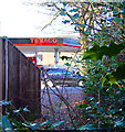
Texaco Petrol Station, Chobham Road
This photo was taken looking across Chobham Road towards the Texaco petrol station on the corner with Bicknell Road. It was taken from a narrow footpath which leads through to Latham Avenue.
Image: © Euchiasmus
Taken: 3 Dec 2007
0.06 miles
3
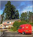
Holly Hedge Close
Holly Hedge Close is a cul-de-sac off Holly Hedge Road in this residential area to the east of Frimley. The row of large mature trees in the distance runs along the boundary between this housing area and the busy A325 Portsmouth Road.
Image: © Euchiasmus
Taken: 3 Dec 2007
0.07 miles
4
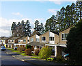
Holly Hedge Road
Looking down Holly Hedge Road, a quiet residential area in Frimley; the magnificent row of trees behind the houses marks the route of the main A325 Portsmouth Road.
Image: © Euchiasmus
Taken: 3 Dec 2007
0.10 miles
5
Portsmouth Road at the junction of Bayfield Avenue
Image: © David Howard
Taken: 7 Jun 2015
0.11 miles
6
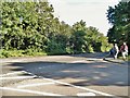
Portsmouth Road at the junction of Bayfield Road
Image: © David Howard
Taken: 7 Jun 2015
0.11 miles
8
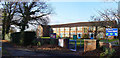
The Grove Primary School
The school first opened in 1959, and prior to 1994 there were separate First and Middle schools on the site. In 1994 they amalgamated to become The Grove Primary School. The school has extensive grounds with a large playing field, three playgrounds, adventure playground equipment and a wildlife area.
This image is a montage of two photographs because of the wide angle involved.
Image: © Euchiasmus
Taken: 3 Dec 2007
0.14 miles
9
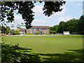
The Grove Primary School
This view of the school shows the large area of playing field. Further details about the school can be seen on the photograph of from Chobham Road at Image
Image: © Euchiasmus
Taken: 1 Aug 2007
0.14 miles
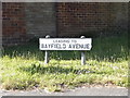
10
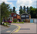
Bayfield Avenue
Houses on Bayfield Avenue, viewed from the end of Blythwood Drive. The tall trees behind mark the route of the main A325 Portsmouth Road.
Image: © Euchiasmus
Taken: 1 Aug 2007
0.14 miles