IMAGES TAKEN NEAR TO
Brunswick Road, CAMBERLEY, GU16 6RN
Introduction
This page details the photographs taken nearby to Brunswick Road, GU16 6RN by members of the Geograph project.
The Geograph project started in 2005 with the aim of publishing, organising and preserving representative images for every square kilometre of Great Britain, Ireland and the Isle of Man.

There are currently over 7.5m images from over14,400 individuals and you can help contribute to the project by visiting https://www.geograph.org.uk
Image Map
Images are licensed for reuse under creativecommons.org/licenses/by-sa/2.0
Notes
- Clicking on the map will re-center to the selected point.
- The higher the marker number, the further away the image location is from the centre of the postcode.
Image Listing (3 Images Found)
Images are licensed for reuse under creativecommons.org/licenses/by-sa/2.0
Image
Details
Distance
1

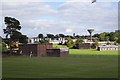
Deepcut Barracks
The Princess Royal Barracks, Deepcut, Surrey, usually referred to as Deepcut Barracks, and prior to 1993 Blackdown Barracks, is the headquarters of the Royal Logistic Corps, (RLC). The barracks are scheduled to close by 2016 and the site is to be redeveloped as a housing estate.
Image: © Len Williams
Taken: 7 Dec 2013
0.10 miles
2
Deepcut Army Camp
Deepcut Camp is the headquarters of the Royal Logistic Corps, which was formed in 1993 from the Royal Corps of Transport, the Royal Army Ordnance Corps, the Royal Pioneer Corps, the Army Catering Corps and the Postal and Courier Section of The Royal Engineers. The Corps provides the rest of the British Army with essential support, including vehicles, spares, equipment, weapons, ammunition, fuel, food and water.
Image: © Ron Strutt
Taken: 29 Sep 2005
0.17 miles
3
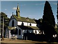
St Barbara, Deepcut
Grade 2 listed building erected in 1900 as a Garrison Church.
Image: © Michael FORD
Taken: Unknown
0.24 miles