IMAGES TAKEN NEAR TO
Henley Drive, CAMBERLEY, GU16 6JT
Introduction
This page details the photographs taken nearby to Henley Drive, GU16 6JT by members of the Geograph project.
The Geograph project started in 2005 with the aim of publishing, organising and preserving representative images for every square kilometre of Great Britain, Ireland and the Isle of Man.

There are currently over 7.5m images from over14,400 individuals and you can help contribute to the project by visiting https://www.geograph.org.uk
Image Map (Loading...)


Getting Data...Please wait
Leaflet Map data © OpenStreetMap
Images are licensed for reuse under creativecommons.org/licenses/by-sa/2.0
Notes
- Clicking on the map will re-center to the selected point.
- The higher the marker number, the further away the image location is from the centre of the postcode.
Image Listing (14 Images Found)
Images are licensed for reuse under creativecommons.org/licenses/by-sa/2.0
Image
Details
Distance
1
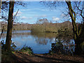
Frimley fishing lakes
The disused gravel pits in the Blackwater Valley now used as a private fishing lake.
Image: © Alan Hunt
Taken: 2 Feb 2014
0.20 miles
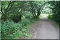
2
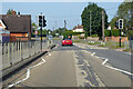
B3411 Frimley Green Road
Heading north.
Image: © Robin Webster
Taken: 26 Sep 2021
0.23 miles
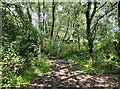
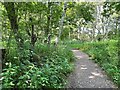
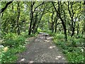
6
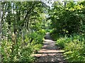
Blackwater Valley Path
The river Blackwater is just visible to the left.
Image: © Fernweh
Taken: 16 Jun 2015
0.23 miles
9
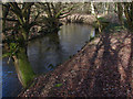
River Blackwater
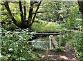
The River Blackwater running between Frimley and Farnborough. The river acts as the boundary between Surrey and Hampshire for much of its length.
Image: © Alan Hunt
Taken: 2 Feb 2014
0.24 miles