IMAGES TAKEN NEAR TO
Range Ride, CAMBERLEY, GU15 4PJ
Introduction
This page details the photographs taken nearby to Range Ride, GU15 4PJ by members of the Geograph project.
The Geograph project started in 2005 with the aim of publishing, organising and preserving representative images for every square kilometre of Great Britain, Ireland and the Isle of Man.

There are currently over 7.5m images from over14,400 individuals and you can help contribute to the project by visiting https://www.geograph.org.uk
Image Map
Images are licensed for reuse under creativecommons.org/licenses/by-sa/2.0
Notes
- Clicking on the map will re-center to the selected point.
- The higher the marker number, the further away the image location is from the centre of the postcode.
Image Listing (5 Images Found)
Images are licensed for reuse under creativecommons.org/licenses/by-sa/2.0
Image
Details
Distance
1
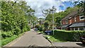
The Breech
In-fill development off College Road.
Image: © James Emmans
Taken: 26 May 2021
0.10 miles
2
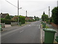
Green wheelie bin collection day, College Road
Image: © don cload
Taken: 26 Jun 2009
0.15 miles
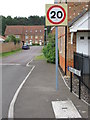
3
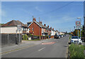
Branksome Hill Road
A suburban residential street, but very different in character from the recently built housing just to the south. No maze of short no through roads here, Branksome Hill Road runs dead straight for over a kilometre lined with a mixture of housing from different decades.
Image: © Des Blenkinsopp
Taken: 18 May 2022
0.23 miles
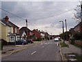
5
Brakes Rise, College Town
A new close squeezed in, off College Road.
Image: © don cload
Taken: 26 Jun 2009
0.25 miles