IMAGES TAKEN NEAR TO
Princess Way, CAMBERLEY, GU15 3SP
Introduction
This page details the photographs taken nearby to Princess Way, GU15 3SP by members of the Geograph project.
The Geograph project started in 2005 with the aim of publishing, organising and preserving representative images for every square kilometre of Great Britain, Ireland and the Isle of Man.

There are currently over 7.5m images from over14,400 individuals and you can help contribute to the project by visiting https://www.geograph.org.uk
Image Map
Images are licensed for reuse under creativecommons.org/licenses/by-sa/2.0
Notes
- Clicking on the map will re-center to the selected point.
- The higher the marker number, the further away the image location is from the centre of the postcode.
Image Listing (136 Images Found)
Images are licensed for reuse under creativecommons.org/licenses/by-sa/2.0
Image
Details
Distance
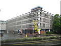
1
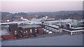
Aerial view from top storey of The Atrium looking across Central Camberley (including Main Square)
With the opening of The Atrium leisure and shopping complex in late 2008, this photograph was taken from the top floor car park - and looks east across the town centre. It shows the roof of 'main square' an enclosed shopping centre, and a number of other buildings (with flat roofs) in nearby Park Street as an aerial view. Some distance beyond the town centre, can be seen plenty of woodland. (Despite this being at the very centre of Camberley, it is several miles from Frimley, by the way)
Image: © Roger
Taken: 9 Jan 2009
0.04 miles
2
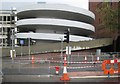
Camberley: The Main Square car park exit ramp
The rain gradually soaks into the concrete wall while an upside down cone thrust into a hole in the ground in the roadworks to make a pedestrian crossing of Pembroke Broadway completes the scene.
Image: © Nigel Cox
Taken: 12 Jun 2011
0.05 miles
3
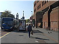
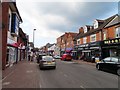
Camberley buses
Buses terminate or pass here.
Ashwood House on the right, built in the early 1980s is currently unoccupied, with BHS, the Post Office and other stores at the rear.
Image: © Sam
Taken: 2 Oct 2015
0.05 miles
4
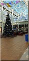
Christmas decorations in Camberley Mall
A large decorated Christmas Tree and hanging decorations in the Main Square of Camberley Mall.
Camberley Mall is an enclosed shopping centre in the centre of Camberley. Each route into the mall has a road name. From this square, in front of O2 is Prince of Wales Walk, to the right is Grace Reynolds Walk, behind the photographer is Cambridge Walk and to the left is Bietigheim Way.
Image: © Oscar
Taken: 4 Dec 2019
0.06 miles
5
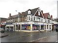
Camberley: Thomas Cook, High Street (Listed Building)
There is only one Nationally Listed Building in Camberley town centre and this is it. The English Heritage website describes it thus:-
"Numbers 72-74 High Street (Anglia Building Society). House, now offices. C17 altered in C19. Timber framed with rendered cladding below, exposed to eaves with rendered infilling; plain tiled roof. Two storeys, 3 framed bays with two 3-light metal diamond pane leaded casement windows across first floor. Two square bay shop windows to ground floor with "Gothick" arched head glazing bars. Two half glazed doors to centre in similar panelled surrounds under blocked transome lights with flanking half pilasters under triglyph capitals. Bracket between doors supporting fascia boards. Flat lintelled throughway to right end."
The Anglia Building Society has long since been subsumed into the Nationwide, while the building next door, 66-68 High Street and occupied by Illuminations, although not listed, appears to be of a similar provenance. The faded road name plate on the building wall above the Thomas Cook sign states "Princess Way" although old Ordnance Survey maps up to 1973 at least call the road "Princess Street".
Image: © Nigel Cox
Taken: 12 Jun 2011
0.06 miles
9
Camberley: The Main Square car park
Surrey Heath Borough Council's car parking map tells us that the car park has 957 spaces, 36 disabled bays and 23 parent and child bays... The road in front is Pembroke Broadway while Albert Road leads to the car park. What more info do you need??!!
Image: © Nigel Cox
Taken: 12 Jun 2011
0.07 miles
10
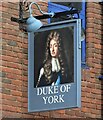
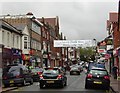
Sign for the Duke of York, Camberley
See Image] for context.
Image: © JThomas
Taken: 27 Jul 2022
0.07 miles