IMAGES TAKEN NEAR TO
Greenbank Way, CAMBERLEY, GU15 2UA
Introduction
This page details the photographs taken nearby to Greenbank Way, GU15 2UA by members of the Geograph project.
The Geograph project started in 2005 with the aim of publishing, organising and preserving representative images for every square kilometre of Great Britain, Ireland and the Isle of Man.

There are currently over 7.5m images from over14,400 individuals and you can help contribute to the project by visiting https://www.geograph.org.uk
Image Map
Images are licensed for reuse under creativecommons.org/licenses/by-sa/2.0
Notes
- Clicking on the map will re-center to the selected point.
- The higher the marker number, the further away the image location is from the centre of the postcode.
Image Listing (28 Images Found)
Images are licensed for reuse under creativecommons.org/licenses/by-sa/2.0
Image
Details
Distance
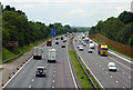
1
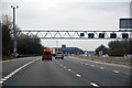
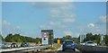
Surrey Heath : M3 Motorway
The M3 Motorway between Junction 3 (Bagshot Interchange) and Junction 4 (Frimley Interchange).
Image: © Lewis Clarke
Taken: 25 Mar 2018
0.04 miles
2
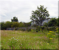
Wild flower meadow adjacent to M3 motorway
Footpaths lead through this large wild flower meadow just north of the M3 motorway. The lorry in the photograph is actually travelling along the M3 towards London, so the proximity of the traffic makes this a very noisy place to take a walk.
Image: © Euchiasmus
Taken: 19 Jul 2007
0.06 miles
3
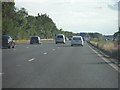
Surrey Heath : The M3
The M3 motorway heading through the Surrey Heath district.
Image: © Lewis Clarke
Taken: 6 Jul 2014
0.06 miles
5
Gate from Gilbert Road to Frimley Park Hospital
At the eastern end of Gilbert Road a fence separates this residential area from the grounds of Frimley Park Hospital. A gate in the fence (beyond the white car in this photo) provides pedestrian access.
Image: © Euchiasmus
Taken: 29 Aug 2007
0.12 miles
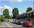
6
Greenbank Way
To the north of these houses, on the left of the photographer, the ground slopes upwards to the M3 motorway. This photograph was taken from partway up the slope. On the left of the road the two cars are parked outside a small nursery school called the "Bright Sparks Montessori School".
Image: © Euchiasmus
Taken: 8 Aug 2007
0.13 miles
7
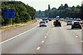
M3 motorway looking west towards junction 4
View of M3 motorway from a footbridge, looking west towards junction 4. This photograph was taken about 13:30 when the traffic was fairly light; during peak periods the traffic can be crawling or stationary along this stretch.
Image: © Euchiasmus
Taken: 19 Jul 2007
0.15 miles
8
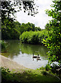
Watchetts Lake
This is the larger of two lakes just north of the M3 motorway. Watchetts Lake is managed by Surrey Heath Leisure Services and footpaths through the woodland surrounding the lakes make a pleasant walk. The island on the right of the photograph masks the full size of this lake.
Image: © Euchiasmus
Taken: 19 Jul 2007
0.16 miles
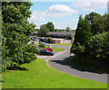
10
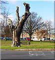
Looking towards Frimley Park Hospital
Photograph taken from the junction of Grovefields Avenue and The Grove (the road in the foreground). The white van and red car are on the busy A325 Portsmouth Road and the buildings beyond it are Frimley Park Hospital. The area of grass in the foreground has a number of mature trees, including one which has seen better days.
Image: © Euchiasmus
Taken: 3 Dec 2007
0.18 miles