IMAGES TAKEN NEAR TO
Wensleydale Drive, CAMBERLEY, GU15 1SP
Introduction
This page details the photographs taken nearby to Wensleydale Drive, GU15 1SP by members of the Geograph project.
The Geograph project started in 2005 with the aim of publishing, organising and preserving representative images for every square kilometre of Great Britain, Ireland and the Isle of Man.

There are currently over 7.5m images from over14,400 individuals and you can help contribute to the project by visiting https://www.geograph.org.uk
Image Map
Images are licensed for reuse under creativecommons.org/licenses/by-sa/2.0
Notes
- Clicking on the map will re-center to the selected point.
- The higher the marker number, the further away the image location is from the centre of the postcode.
Image Listing (32 Images Found)
Images are licensed for reuse under creativecommons.org/licenses/by-sa/2.0
Image
Details
Distance
1
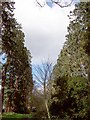
Wellingtonia Pine Avenue 1
An avenue of Wellingtonia pines stretched from the Upper Chobham Road to Brookwood House, (now the Ridgewood Centre). This photo shows the top of the avenue as seen from where it crosses Inglewood Avenue. For another view along the avenue refer to picture Image For a view of the avenue in 2016 refer to picture Image
Image: © Len Williams
Taken: 30 Mar 2008
0.05 miles
2

Cottages on the Upper Chobham Road
These cottages, probably built for the Brookwood House estate workers, have been upgraded into desirable "des res" houses, but still retain their charm reflecting their original design.
Image: © Len Williams
Taken: 1 Sep 2009
0.06 miles
3
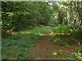
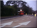
Pirbright Range
The wooded edge of the range area alongside the Maultway.
Image: © Alan Hunt
Taken: 14 Aug 2011
0.06 miles
6
Inglewood Avenue, Camberley
A view along Inglewood Avenue in the Heatherwood estate.
Image: © Alan Hunt
Taken: 14 Aug 2011
0.08 miles
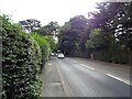
7
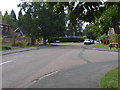
Junction of The Maultway and Upper Chobham Road
Image: © David Howard
Taken: 11 Jan 2012
0.08 miles
8
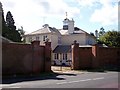
The Gatehouse
This charming building, now called Heatheridge House, appears to be the original gatehouse allowing traffic from the Upper Chobham Road to access Longlands Way, an avenue of wellingtonia pine trees, which formed the drive to Brookwood House at the South of the original estate. Some of the trees can be seen on the left of the picture. Refer to the associated squares to the South to view Longlands Way.
Image: © Len Williams
Taken: 1 Sep 2009
0.08 miles
9
Inglewood Avenue
The crossing point of the Wellingtonia Avenue with Inglewood Avenue.
Image: © Alan Hunt
Taken: 14 Aug 2011
0.08 miles
10
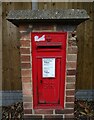
George V postbox on Upper Chobham Road, Camberley
Postbox No. GU15 11.
Image: © JThomas
Taken: 25 Jul 2022
0.09 miles