IMAGES TAKEN NEAR TO
Greenhill Close, CAMBERLEY, GU15 1PG
Introduction
This page details the photographs taken nearby to Greenhill Close, GU15 1PG by members of the Geograph project.
The Geograph project started in 2005 with the aim of publishing, organising and preserving representative images for every square kilometre of Great Britain, Ireland and the Isle of Man.

There are currently over 7.5m images from over14,400 individuals and you can help contribute to the project by visiting https://www.geograph.org.uk
Image Map
Images are licensed for reuse under creativecommons.org/licenses/by-sa/2.0
Notes
- Clicking on the map will re-center to the selected point.
- The higher the marker number, the further away the image location is from the centre of the postcode.
Image Listing (17 Images Found)
Images are licensed for reuse under creativecommons.org/licenses/by-sa/2.0
Image
Details
Distance
1
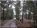
MOD test track
This area near White Hill is covered in tracks which are used for a high speed vehicle testing area.
Image: © don cload
Taken: 23 Feb 2010
0.08 miles
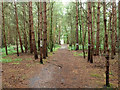
2
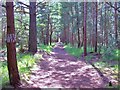
Walking to High Curley
Looking back towards the start to the path to High Curley Hill. The path leaves The Maultway and runs through the old army driving test course, now used by car and scrambling clubs, to the summit of High Curley hill which give fine view towards London and North Surrey. Refer to picture Image for the opposite view.
Image: © Len Williams
Taken: 6 Aug 2014
0.10 miles
3
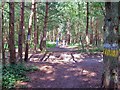
Walking to High Curley
This picture shows the path from The Maultway to High Curley hill as it crosses some of the tracks cleared by the army for training 'rough road' drivers. The area now seems to be used exclusively by car clubs and scrambling associations. Refer to picture Image for the point where the track crosses from the MoD land to Lighwater Country Park.
Image: © Len Williams
Taken: 6 Aug 2014
0.12 miles
4
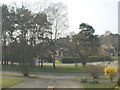
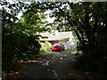
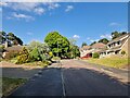
Copped Hall Estate, Camberley
Looking across the green 'island' between Green Hill Close and Green Hill Road.
Image: © Andrew Pepper
Taken: 27 Mar 2003
0.13 miles
5
Camberley - Copped Hall Drive
Bungalow near Bagshot Heath
Image: © James Emmans
Taken: 9 Jul 2017
0.14 miles
6
Public bridleway through military vehicle testing area
It seems the route does not quite coincide with that mapped, but it is clearly indicated with white marks on the trees.
Image: © Robin Webster
Taken: 27 Aug 2015
0.14 miles
7
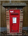
George V postbox on Upper Chobham Road, Camberley
Postbox No. GU15 11.
Image: © JThomas
Taken: 25 Jul 2022
0.20 miles
9
Navigating northwards up the Basher (28)
Lamppost in Roundway
Image: © Basher Eyre
Taken: 5 Jun 2023
0.21 miles
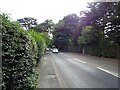
10
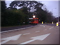
Junction of The Maultway and Upper Chobham Road
Image: © David Howard
Taken: 11 Jan 2012
0.21 miles