IMAGES TAKEN NEAR TO
The Fairway, CAMBERLEY, GU15 1EF
Introduction
This page details the photographs taken nearby to The Fairway, GU15 1EF by members of the Geograph project.
The Geograph project started in 2005 with the aim of publishing, organising and preserving representative images for every square kilometre of Great Britain, Ireland and the Isle of Man.

There are currently over 7.5m images from over14,400 individuals and you can help contribute to the project by visiting https://www.geograph.org.uk
Image Map
Images are licensed for reuse under creativecommons.org/licenses/by-sa/2.0
Notes
- Clicking on the map will re-center to the selected point.
- The higher the marker number, the further away the image location is from the centre of the postcode.
Image Listing (17 Images Found)
Images are licensed for reuse under creativecommons.org/licenses/by-sa/2.0
Image
Details
Distance
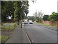
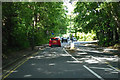
2
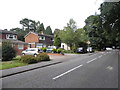
Evergreen Road - Frimley
A wet and dull January day.
Image: © James Emmans
Taken: 8 Jan 2022
0.16 miles
3
Evergreen Road
Residential road off the Chobham Road.
Image: © James Emmans
Taken: 8 Jan 2022
0.16 miles
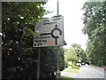
5
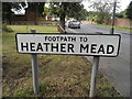
Old path sign on Evergreen Road, Frimley
Image: © David Howard
Taken: 27 Jul 2015
0.18 miles
6
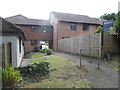
Path between Evergreen Road and Heather Mead
The room on the bridge may well have a flying freehold, which describes legal ownership of a part of a building above someone else's land.
Image: © David Howard
Taken: 27 Jul 2015
0.20 miles
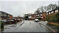
7
Chobham Road at the junction of Old Bisley Road
Image: © David Howard
Taken: 27 Jul 2015
0.20 miles
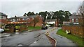
8
Old Bisley Road
Heading west towards the centre of Frimley and about to join A311 Chobham Road.
Image: © Robin Webster
Taken: 9 Jun 2019
0.20 miles
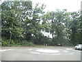
9
Roundabout sign on Chobham Road, Frimley
Image: © David Howard
Taken: 27 Jul 2015
0.20 miles