IMAGES TAKEN NEAR TO
Burwood Close, GUILDFORD, GU1 2SB
Introduction
This page details the photographs taken nearby to Burwood Close, GU1 2SB by members of the Geograph project.
The Geograph project started in 2005 with the aim of publishing, organising and preserving representative images for every square kilometre of Great Britain, Ireland and the Isle of Man.

There are currently over 7.5m images from over14,400 individuals and you can help contribute to the project by visiting https://www.geograph.org.uk
Image Map
Images are licensed for reuse under creativecommons.org/licenses/by-sa/2.0
Notes
- Clicking on the map will re-center to the selected point.
- The higher the marker number, the further away the image location is from the centre of the postcode.
Image Listing (114 Images Found)
Images are licensed for reuse under creativecommons.org/licenses/by-sa/2.0
Image
Details
Distance
1
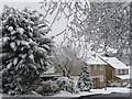
Kingswood Close
Unaccustomed April snow in a suburban Guildford street. The snow had gone by lunchtime.
Image: © Colin Smith
Taken: 6 Apr 2008
0.02 miles
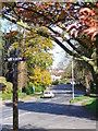
2
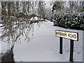
Wykeham Road
More of a crescent than a road, in suburban Guildford.
Early April snow on the mainly inter-war Bushy Hill Estate.
Image: © Colin Smith
Taken: 6 Apr 2008
0.06 miles
3
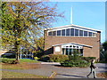
Merrow Methodist Church
Brick building at the corner of Bushy Hill Drive and Sheeplands Avenue. Its foundation stone was laid in 1968. To the left, behind the tree, is the church hall which is used by local societies like Brownies and Toddlers' Group.
Image: © Colin Smith
Taken: 30 Oct 2007
0.07 miles
4
Epsom Road, Merrow
The old village centre is now very suburban. Above are a hairdresser, a charity shop, car wash / BP garage / supermarket and a block of flats with more shops on the ground floor. Here is the local newsagent.
Image: © Colin Smith
Taken: 27 Aug 2007
0.08 miles
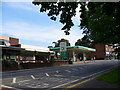
5
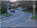
The Epsom Road, Merrow
Looking east along the A25 Epsom Road towards the double bend before the shops. The traffic lights are at the junction with Bushy Hill Drive.
Image: © Alan Hunt
Taken: 1 Mar 2014
0.08 miles
6
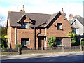
Tollgate Cottage, Merrow
This 19th century tile-hung cottage has been built on the site of the original toll house on Epsom Road. The tolls were abolished in 1867 and the cottage was demolished before being replaced. It's closing tariff was "4d a horse; 10d per score of bullocks; 5d per score of sheep" - not many of these beasts are seen today on Epsom Road!
Image: © Colin Smith
Taken: 1 Nov 2007
0.09 miles
7
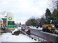
Snowplough on Epsom Road
Gritting lorries with snowploughs are a common sight in Guildford this week. This one is passing the BP Filling Station in Merrow.
Image: © Colin Smith
Taken: 3 Feb 2009
0.10 miles
8
Epsom Road, Merrow
An uncharacteristically quiet view of this main arterial road heading east out of Guildford. Note the village sign with its race horse - Merrow once had a race course on its Downs where the golf course is today.
Image: © Colin Smith
Taken: 1 Nov 2007
0.10 miles
9
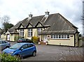
Merrow Village Club & Hall (1), 177 Epsom Road, Merrow, Guildford
Although Merrow was at one time a village, its huge expansion in recent decades has meant it has become another one of Guildford's suburbs. A relic of its days as a village is Merrow Village Club & Hall. A photo in the Francis Frith Collection from 1913, shows the outside of the hall very much as it is today, apart from the entrance area.
Image
Image
Image
Image: © P L Chadwick
Taken: 10 Mar 2011
0.10 miles
10
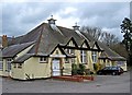
Merrow Village Club & Hall (2), 177 Epsom Road, Merrow, Guildford
The hall is used by various local groups. The building is divided between the hall and the social club. Merrow Village Club & Hall was established in 1921, and is registered as a friendly society. The building is older, as there is a photograph of it in the Francis Frith collection, which is dated 1913.
More photographs:- Image
Image: © P L Chadwick
Taken: 10 Mar 2011
0.10 miles