IMAGES TAKEN NEAR TO
Wyke Avenue, ALDERSHOT, GU12 6EA
Introduction
This page details the photographs taken nearby to Wyke Avenue, GU12 6EA by members of the Geograph project.
The Geograph project started in 2005 with the aim of publishing, organising and preserving representative images for every square kilometre of Great Britain, Ireland and the Isle of Man.

There are currently over 7.5m images from over14,400 individuals and you can help contribute to the project by visiting https://www.geograph.org.uk
Image Map
Images are licensed for reuse under creativecommons.org/licenses/by-sa/2.0
Notes
- Clicking on the map will re-center to the selected point.
- The higher the marker number, the further away the image location is from the centre of the postcode.
Image Listing (27 Images Found)
Images are licensed for reuse under creativecommons.org/licenses/by-sa/2.0
Image
Details
Distance
1

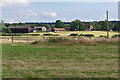
Fields by Wyke
View across cereal fields to houses on Wyke Avenue, backed by deciduous woodland.
Image: © Colin Smith
Taken: 11 Jul 2012
0.08 miles
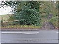
2

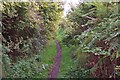
Follyhatch Lane
The footpath known as Follyhatch lane with one of the houses at the bottom of Wyke Avenue
Image: © Alan Hunt
Taken: 30 Jul 2011
0.10 miles
3
Byway at Wyke
Legally you are allowed to drive a motor vehicle along this track, but fortunately no-one seems to have tried for a very long time. This was by no means the narrowest part! The byway connects the A323 at its junction with the A324 with Westwood Lane.
Image: © Ron Strutt
Taken: 29 Sep 2005
0.11 miles
4
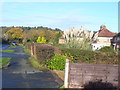
Wyke Lane
Quiet residential lane at Wyke, the west end of Normandy village.
Image: © Colin Smith
Taken: 30 Nov 2011
0.11 miles
5
View towards East Wyke Farm
Looking south from the footpath across Shortland Farm towards East Wyke Farm.
Image: © Alan Hunt
Taken: 13 Aug 2016
0.15 miles
6
Field near Wyke
A long field of barley south of the Guildford Road. Note the wide margins with an abundance of wild flowers and grasses - very good for wildlife.
Image: © Alan Hunt
Taken: 30 Jul 2011
0.17 miles
7

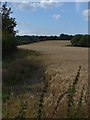
Barley Field near Wyke
Large field of ripening barley on the east side of Follyhatch Lane.
Image: © Colin Smith
Taken: 11 Jul 2012
0.17 miles
9
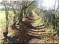
Wintry Wyke
Bare trees lining the footpath heading west from Wyke Lane.
Image: © Colin Smith
Taken: 30 Nov 2011
0.18 miles
10
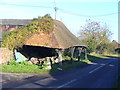
Wyke Farm
Open-sided, roadside barn at West Wyke Farm near Ash. East Wyke Farm faces the barn (from right).
Image: © Colin Smith
Taken: 30 Nov 2011
0.19 miles