IMAGES TAKEN NEAR TO
Crescent Lane, ALDERSHOT, GU12 5EE
Introduction
This page details the photographs taken nearby to Crescent Lane, GU12 5EE by members of the Geograph project.
The Geograph project started in 2005 with the aim of publishing, organising and preserving representative images for every square kilometre of Great Britain, Ireland and the Isle of Man.

There are currently over 7.5m images from over14,400 individuals and you can help contribute to the project by visiting https://www.geograph.org.uk
Image Map
Images are licensed for reuse under creativecommons.org/licenses/by-sa/2.0
Notes
- Clicking on the map will re-center to the selected point.
- The higher the marker number, the further away the image location is from the centre of the postcode.
Image Listing (53 Images Found)
Images are licensed for reuse under creativecommons.org/licenses/by-sa/2.0
Image
Details
Distance
1
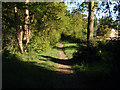
Ash Ranges
Path leading from the range fence towards Prospect Road.
Image: © Alan Hunt
Taken: 22 May 2010
0.02 miles
5
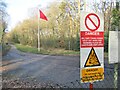
Ash Vale Ranges
Red flag and danger signs at a military training area near Aldershot, the "Home of the British Army".
Image: © Colin Smith
Taken: 1 Feb 2020
0.06 miles
7
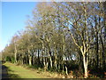
Birch trees in winter
These birch trees are on the edge of Ash Ranges by the boundary road.
Image: © don cload
Taken: 9 Jan 2011
0.08 miles