IMAGES TAKEN NEAR TO
Slyfield Court, GUILDFORD, GU1 1RJ
Introduction
This page details the photographs taken nearby to Slyfield Court, GU1 1RJ by members of the Geograph project.
The Geograph project started in 2005 with the aim of publishing, organising and preserving representative images for every square kilometre of Great Britain, Ireland and the Isle of Man.

There are currently over 7.5m images from over14,400 individuals and you can help contribute to the project by visiting https://www.geograph.org.uk
Image Map
Images are licensed for reuse under creativecommons.org/licenses/by-sa/2.0
Notes
- Clicking on the map will re-center to the selected point.
- The higher the marker number, the further away the image location is from the centre of the postcode.
Image Listing (60 Images Found)
Images are licensed for reuse under creativecommons.org/licenses/by-sa/2.0
Image
Details
Distance
1
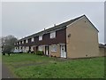
Slyfield - Terrace Housing in Waterside Road
Image: © James Emmans
Taken: 30 Dec 2018
0.04 miles
2
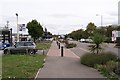
Slyfield housing estate
The housing estate to the south of the Slyfield industrial area in Guildford.
Image: © Alan Hunt
Taken: 27 Feb 2016
0.05 miles
3
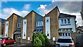
Houses in Woodlands Close
At least I think this is Woodlands Close, according to Google Maps.
Image: © Ian Hawfinch
Taken: 12 Nov 2020
0.07 miles
4
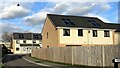
Houses off Slyfield Green
I've only captured the first three letters of the road sign on the right. It looks as though it may read "Lock something" - which would make sense, given that Stoke Lock is nearby. I tried to check the name on Google Maps, but some of these roads are quite new and don't show up. There's some kind of pigeon in mid-flight in the top left of the photo!
Image: © Ian Hawfinch
Taken: 12 Nov 2020
0.08 miles
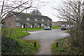
5
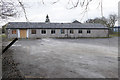
Disused club house, Slyfield
A disused and boarded up former club house on the edge of the Slyfield housing estate in Guildford.
Image: © Alan Hunt
Taken: 27 Feb 2016
0.10 miles
6
Slyfield Industrial Estate
One of north Guildford's main industrial areas, and also the site of the local sewage works and waste disposal. Car dealerships seem to find this a popular spot. It was also the site, from 1969 until it closed in May 2000, of Guildford's cattle market.
Image: © Ron Strutt
Taken: 26 Sep 2005
0.13 miles
7
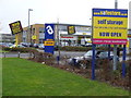
Storage Room
Guildford's Slyfield Industrial Estate now has a cluster of storage facilities amidst the car showrooms on Moorfield Road. Here are the Safestore and the Big Yellow Self Storage companies.
Image: © Colin Smith
Taken: 15 Mar 2008
0.15 miles
8
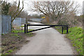
Slyfield sewage works road
The barrier across the access road just past the entrance to the sewage works in Slyfield. The track carries on to the Stoke Lock on the River Wey navigation.
Image: © Alan Hunt
Taken: 27 Feb 2016
0.17 miles
9
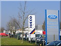
Moorfield Road, Slyfield Industrial Estate
A definite case of functional agglomeration as garages and car showrooms vie for business in this north Guildford road. Dennis also had a bus factory in this road till very recently (previously, Dennis made fire engines in Guildford for many decades).
Image: © Colin Smith
Taken: 2 Apr 2007
0.18 miles
10

F. G. Barnes to L.I.Brary (3)
Lookers, Volkswagen, Moorfield Road. Maybe John Inverdale is a customer https://www.bbc.co.uk/news/uk-23214821
Image: © Basher Eyre
Taken: 26 Jul 2021
0.19 miles