IMAGES TAKEN NEAR TO
Lyndhurst Avenue, ALDERSHOT, GU11 3RW
Introduction
This page details the photographs taken nearby to Lyndhurst Avenue, GU11 3RW by members of the Geograph project.
The Geograph project started in 2005 with the aim of publishing, organising and preserving representative images for every square kilometre of Great Britain, Ireland and the Isle of Man.

There are currently over 7.5m images from over14,400 individuals and you can help contribute to the project by visiting https://www.geograph.org.uk
Image Map
Images are licensed for reuse under creativecommons.org/licenses/by-sa/2.0
Notes
- Clicking on the map will re-center to the selected point.
- The higher the marker number, the further away the image location is from the centre of the postcode.
Image Listing (28 Images Found)
Images are licensed for reuse under creativecommons.org/licenses/by-sa/2.0
Image
Details
Distance
1
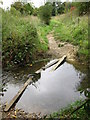
Unofficial stepping stones
These old concrete posts have been placed in a narrow section of the River Blackwater to create a crossing point that appears to be well used.
Image: © don cload
Taken: 4 Oct 2011
0.08 miles
2
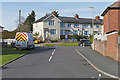
Selbourne Avenue, Aldershot
The junction of Selbourne Avenue with Morland Road.
Image: © Alan Hunt
Taken: 25 Mar 2016
0.14 miles
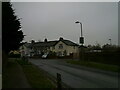
3
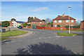
Pool Road junction, Aldershot
The junction of Pool Road with Gloucester Road.
Image: © Alan Hunt
Taken: 25 Mar 2016
0.14 miles
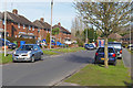
4
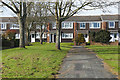
Houses on Selbourne Avenue, Aldershot
A terrace in the 1970s housing estate off Selbourne Avenue.
Image: © Alan Hunt
Taken: 25 Mar 2016
0.18 miles
5
Looking from Lower Farnham Road into Morland Road
Image: © Basher Eyre
Taken: 8 Dec 2022
0.20 miles
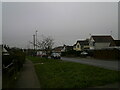
6
Morland Road, Aldershot
Morland Road, a residential street near Aldershot Park dating from the late 1950s.
Image: © Alan Hunt
Taken: 25 Mar 2016
0.21 miles
7

Pool Road, Aldershot
Flats on Pool Road near Aldershot Park.
Image: © Alan Hunt
Taken: 25 Mar 2016
0.21 miles
8

Houses along the Blackwater, Aldershot
A terrace at the end of Short Dale Road facing the River Blackwater.
Image: © Alan Hunt
Taken: 25 Mar 2016
0.21 miles
9
Approaching the crossroads of Lower Farnham Lane with Morland Road and Boxall's Lane
Image: © Basher Eyre
Taken: 8 Dec 2022
0.21 miles
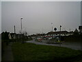
10
Wide verges in Lower Farnham Road
Which often means it was originally built with extra capacity in mind, should it be needed.
Image: © Basher Eyre
Taken: 8 Dec 2022
0.22 miles