IMAGES TAKEN NEAR TO
Boundary Road, FARNHAM, GU10 4ET
Introduction
This page details the photographs taken nearby to Boundary Road, GU10 4ET by members of the Geograph project.
The Geograph project started in 2005 with the aim of publishing, organising and preserving representative images for every square kilometre of Great Britain, Ireland and the Isle of Man.

There are currently over 7.5m images from over14,400 individuals and you can help contribute to the project by visiting https://www.geograph.org.uk
Image Map
Images are licensed for reuse under creativecommons.org/licenses/by-sa/2.0
Notes
- Clicking on the map will re-center to the selected point.
- The higher the marker number, the further away the image location is from the centre of the postcode.
Image Listing (7 Images Found)
Images are licensed for reuse under creativecommons.org/licenses/by-sa/2.0
Image
Details
Distance
1
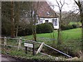
Cottage with crocuses
This is at the west end of West End Lane.
Image: © Shazz
Taken: 3 Mar 2011
0.05 miles
2
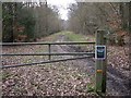
Entrance to Alice Holt Forest
There is a poster displayed which is against the government's proposed sell-off of forest land.
Image: © Shazz
Taken: 3 Mar 2011
0.09 miles
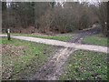
3
Track, Alice Holt Forest
In the Glenbervie Inclosure part of the Forestry Commission woodland.
Image: © Robin Webster
Taken: 30 Jul 2015
0.11 miles
4
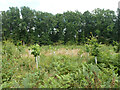
Replanted area, Glenbervie Inclosure, Alice Holt Forest
They appear to be a species of oak.
Image: © Robin Webster
Taken: 30 Jul 2015
0.17 miles
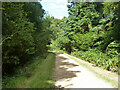
5
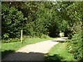
A main track, Alice Holt Forest
In the Glenbervie Inclosure part of the Forestry Commission woodland. An information board is on the left.
Image: © Robin Webster
Taken: 30 Jul 2015
0.18 miles
6
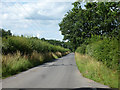
Boundary Road
The boundary is between Hampshire and Surrey, although the road is in Surrey with the actual boundary a narrow field width away to the left along the edge of Alice Holt Forest.
Image: © Robin Webster
Taken: 30 Jul 2015
0.19 miles