IMAGES TAKEN NEAR TO
Frensham Heights Road, FARNHAM, GU10 4EA
Introduction
This page details the photographs taken nearby to Frensham Heights Road, GU10 4EA by members of the Geograph project.
The Geograph project started in 2005 with the aim of publishing, organising and preserving representative images for every square kilometre of Great Britain, Ireland and the Isle of Man.

There are currently over 7.5m images from over14,400 individuals and you can help contribute to the project by visiting https://www.geograph.org.uk
Image Map
Images are licensed for reuse under creativecommons.org/licenses/by-sa/2.0
Notes
- Clicking on the map will re-center to the selected point.
- The higher the marker number, the further away the image location is from the centre of the postcode.
Image Listing (4 Images Found)
Images are licensed for reuse under creativecommons.org/licenses/by-sa/2.0
Image
Details
Distance
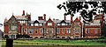
1
Frensham Heights School
Large co-educational school, for day pupils and boarders, in a rural situation south of Farnham.
www.frensham-pc.gov.uk
www.frenshamheights.org
Image: © Colin Smith
Taken: 7 Jan 2012
0.01 miles
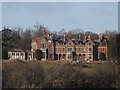
2
Frensham Hill, Rowledge
Very long and large neo-Tudor house peppered with quite a display of towers, turrets, chimneys and gables. Built c1900 for the Charringtons brewing family to the designs of F.W. Waller of Gloucester.
It is now a private school, Frensham Heights.
The date of the photo is uncertain. There is a much better one here: Image
Image: © Stephen Richards
Taken: Unknown
0.01 miles
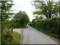
3

Frensham Heights
Wooded ridge south of Farnham with a large co-educational school carrying the same name.
www.frenshamheights.org
www.frensham-pc.gov.uk
Image: © Colin Smith
Taken: 7 Jan 2012
0.08 miles