IMAGES TAKEN NEAR TO
Churt Road, FARNHAM, GU10 2QS
Introduction
This page details the photographs taken nearby to Churt Road, GU10 2QS by members of the Geograph project.
The Geograph project started in 2005 with the aim of publishing, organising and preserving representative images for every square kilometre of Great Britain, Ireland and the Isle of Man.

There are currently over 7.5m images from over14,400 individuals and you can help contribute to the project by visiting https://www.geograph.org.uk
Image Map
Images are licensed for reuse under creativecommons.org/licenses/by-sa/2.0
Notes
- Clicking on the map will re-center to the selected point.
- The higher the marker number, the further away the image location is from the centre of the postcode.
Image Listing (5 Images Found)
Images are licensed for reuse under creativecommons.org/licenses/by-sa/2.0
Image
Details
Distance
1
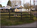
Mayfair Farm on Churt Road
Here is the farm sign with part of the yard and the chicken house.
Image: © Shazz
Taken: 11 Feb 2010
0.03 miles
2
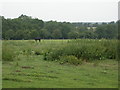
Paddock
Paddock near Elliot's Farm near northern edge of the square.
Image: © Ben Gamble
Taken: 26 Jun 2005
0.10 miles
3
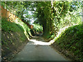
Bacon Lane
A sunken lane as it descends a hill, typical where there is sandstone geology. According to the Geology of Britain website, the geology here is "Bargate Sandstone Member - Sandstone. Sedimentary Bedrock formed approximately 112 to 125 million years ago in the Cretaceous Period. Local environment previously dominated by shallow seas."
Image: © Robin Webster
Taken: 8 Jun 2014
0.11 miles
5
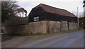
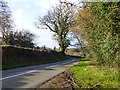
Barn on Churt Road
Smithfield Lane is off to the left.
Image: © Shazz
Taken: 11 Feb 2010
0.23 miles