IMAGES TAKEN NEAR TO
Tilford Road, FARNHAM, GU10 2BX
Introduction
This page details the photographs taken nearby to Tilford Road, GU10 2BX by members of the Geograph project.
The Geograph project started in 2005 with the aim of publishing, organising and preserving representative images for every square kilometre of Great Britain, Ireland and the Isle of Man.

There are currently over 7.5m images from over14,400 individuals and you can help contribute to the project by visiting https://www.geograph.org.uk
Image Map
Images are licensed for reuse under creativecommons.org/licenses/by-sa/2.0
Notes
- Clicking on the map will re-center to the selected point.
- The higher the marker number, the further away the image location is from the centre of the postcode.
Image Listing (92 Images Found)
Images are licensed for reuse under creativecommons.org/licenses/by-sa/2.0
Image
Details
Distance
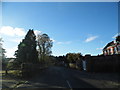
2
Stately home on Tilford Road
This is one of a number of similar buildings on the estate but do not know the history.
Image: © David Howard
Taken: 14 Oct 2012
0.02 miles
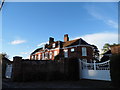
3
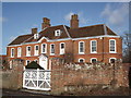
Tilford House
Historic manor house, dating back to ca. 1740, in the village of Tilford.
Image: © Colin Smith
Taken: 22 Jan 2012
0.03 miles
4
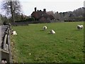
Sheep at Tilford
There is always a small flock of sheep in this field and they always gladden my heart. Beyond the sheep the picture is in the next grid square to the east.
Image: © Shazz
Taken: 6 Mar 2011
0.04 miles
5
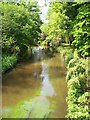
River Wey (South branch)
A view from Tilford West Bridge of the River Wey, (South branch), which extends to Frensham Little Pond.
Image: © Len Williams
Taken: 24 May 2012
0.05 miles
6
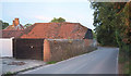
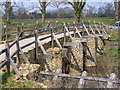
Barn, Tilford
At the west end of the village. Above it on the left is part of the roof of the grade II* listed Tilford House https://historicengland.org.uk/listing/the-list/list-entry/1352763 .
Image: © Derek Harper
Taken: 17 Aug 2019
0.06 miles
7
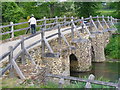
Tilford West Bridge
This bridge dates from the 13th century, from the building of nearby Waverley Abbey. The bridge is now by-passed by the modern one lane road bridge.
Image: © Colin Smith
Taken: 10 May 2009
0.07 miles
8
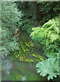
River Wey
Looking upstream from the medieval bridge shown in http://www.geograph.org.uk/search.php?i=114251142 .
Image: © Derek Harper
Taken: 17 Aug 2019
0.08 miles
9
Medieval Stone Bridge, Tilford
This is one of Tilford's two medieval stone bridges. The current road bridge parallels the old bridge to the east. Under the bridge flows the River Wey (South Branch).
Image: © Colin Smith
Taken: 31 Mar 2007
0.08 miles
10
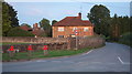
Tilford House Farmhouse
Listed and described at https://historicengland.org.uk/listing/the-list/list-entry/1352765 :"Timber framed to right with brick infill, once colourwashed and now worn away, some in diagonal pattern, Bargate stone rubble with brick dressings to left". In the foreground is the junction shown in Image As with Image], part of the roof of the grade II* listed Tilford House https://historicengland.org.uk/listing/the-list/list-entry/1352763 can be seen on the left.
Image: © Derek Harper
Taken: 17 Aug 2019
0.08 miles