IMAGES TAKEN NEAR TO
Kingscote, TETBURY, GL8 8YA
Introduction
This page details the photographs taken nearby to GL8 8YA by members of the Geograph project.
The Geograph project started in 2005 with the aim of publishing, organising and preserving representative images for every square kilometre of Great Britain, Ireland and the Isle of Man.

There are currently over 7.5m images from over14,400 individuals and you can help contribute to the project by visiting https://www.geograph.org.uk
Image Map
Images are licensed for reuse under creativecommons.org/licenses/by-sa/2.0
Notes
- Clicking on the map will re-center to the selected point.
- The higher the marker number, the further away the image location is from the centre of the postcode.
Image Listing (17 Images Found)
Images are licensed for reuse under creativecommons.org/licenses/by-sa/2.0
Image
Details
Distance
1
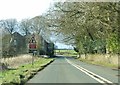
Approaching a staggered crossroads
The A4135 approaching a road junction near Kingscote from the south-east.
Image: © Ruth Riddle
Taken: 3 Mar 2012
0.04 miles
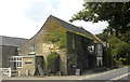
2

Hunters Hall Inn near Kingscote, Glos.
Image: © Steve Fareham
Taken: 3 Mar 2010
0.05 miles
3

Hunters Hall, nr Kingscote, Gloucestershire 2013
Image: © Ray Bird
Taken: 8 Aug 2013
0.06 miles
4
Hunters Hall, nr Kingscote, Gloucestershire 2013
Image: © Ray Bird
Taken: 8 Aug 2013
0.06 miles
5
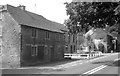
Hunters Hall, nr Kingscote, Gloucestershire 2013
Image: © Ray Bird
Taken: 8 Aug 2013
0.08 miles
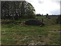
7
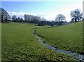
Hay Bottom
A tiny brook meanders through idyllic pastureland.
Image: © Roger Cornfoot
Taken: 25 Jan 2007
0.20 miles
8
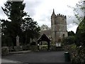
Kingscote (Glos) St John's Church and War Memorial
Image: © ChurchCrawler
Taken: Unknown
0.20 miles
9
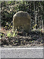
Old Milestone by the A4135, Kingscote Park, Kingscote parish
Stone post (plate lost) by the A4135, in parish of KINGSCOTE (COTSWOLD District), by the road, on South side of road. TDW iron plate, erected by the Coldharbour District turnpike trust in the 19th century.
Inscription once read:-
(TETBURY)
(5)
(DURSLEY)
(&)
(WOTTON)
(5)
Grade II listed.
List Entry Number: 1153577 https://historicengland.org.uk/listing/the-list/list-entry/1153577
Milestone Society National ID: GL_TBDY05.
Image: © Roadside Relics
Taken: 12 Feb 2024
0.21 miles
10
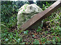
Milestone, A4135
Stone post (plate lost) by the A4135, in parish of KINGSCOTE (COTSWOLD District), by the road, on South side of road. TDW iron plate, erected by the Coldharbour District turnpike trust in the 19th century.
Inscription once read: TETBURY / 5 / DURSLEY / & / WOTTON / 5
Grade II listed see https://historicengland.org.uk/listing/the-list/list-entry/1153577
Milestone Society National ID: GL_TBDY05
Image: © Mr Red
Taken: 29 Jul 2021
0.21 miles