IMAGES TAKEN NEAR TO
Nesley, TETBURY, GL8 8UA
Introduction
This page details the photographs taken nearby to Nesley, GL8 8UA by members of the Geograph project.
The Geograph project started in 2005 with the aim of publishing, organising and preserving representative images for every square kilometre of Great Britain, Ireland and the Isle of Man.

There are currently over 7.5m images from over14,400 individuals and you can help contribute to the project by visiting https://www.geograph.org.uk
Image Map
Images are licensed for reuse under creativecommons.org/licenses/by-sa/2.0
Notes
- Clicking on the map will re-center to the selected point.
- The higher the marker number, the further away the image location is from the centre of the postcode.
Image Listing (5 Images Found)
Images are licensed for reuse under creativecommons.org/licenses/by-sa/2.0
Image
Details
Distance
1
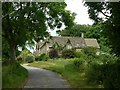
Lodge Cottage, Nesley
At the entrance to the drive to Nesley Farm.
Image: © Alan Murray-Rust
Taken: 27 Jun 2017
0.00 miles
2
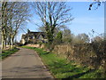
Approaching Nesley Farm.
A view looking to the northwest along the lane from Hookshouses , towards the buildings at the entrance to Nesley Farm.
Image: © Phil Williams
Taken: 25 Jan 2007
0.01 miles
3
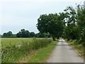
Looking towards Hookshouse
Cotswold Country lane.
Image: © Alan Murray-Rust
Taken: 27 Jun 2017
0.09 miles
4
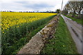
Road near Nestley Farm
Country road to the south-east of Nestley Farm. The oilseed rape crop as always adds a splash of colour.
Image: © Philip Halling
Taken: 21 Apr 2012
0.15 miles
5
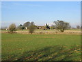
Nesley Farm
A view looking to the north across farmland towards Nesley Farm.
Image: © Phil Williams
Taken: 25 Jan 2007
0.16 miles