IMAGES TAKEN NEAR TO
Stroud Road, CIRENCESTER, GL7 6LB
Introduction
This page details the photographs taken nearby to Stroud Road, GL7 6LB by members of the Geograph project.
The Geograph project started in 2005 with the aim of publishing, organising and preserving representative images for every square kilometre of Great Britain, Ireland and the Isle of Man.

There are currently over 7.5m images from over14,400 individuals and you can help contribute to the project by visiting https://www.geograph.org.uk
Image Map
Images are licensed for reuse under creativecommons.org/licenses/by-sa/2.0
Notes
- Clicking on the map will re-center to the selected point.
- The higher the marker number, the further away the image location is from the centre of the postcode.
Image Listing (7 Images Found)
Images are licensed for reuse under creativecommons.org/licenses/by-sa/2.0
Image
Details
Distance
1
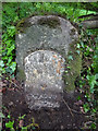
Milestone A419, Coates
Stroud 10 miles. Opposite Four Mile Lodge
includes an Ordnance Survey Bench Mark 159.9m ASL (LHS under soil). More BMs in the area see http://benchmarks.mister.red/#coates
Cirencester 4 / Stroud 10
Milestone Society ID: GL_CISD04
Image: © Mr Red
Taken: 17 May 2019
0.02 miles
2
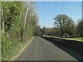
Un-named road approaches junction with A419
Image: © Stuart Logan
Taken: 28 Mar 2012
0.08 miles
3
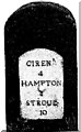
Old Milestone by the A419, Three Mile Bottom, Coates Parish
Metal plate attached to stone post by the A419, in parish of COATES (COTSWOLD District), Three Mile Bottom; opposite Four Mile Lodge, just west of traffic sign, on South side of road. Cirencester roundhead iron plate, erected by the Cirencester to Stroud turnpike trust in the 19th century.
Inscription reads:- : CIREN.R / 4 / HAMPTON / 8 / STROUD / 10 :
Milestone Society National ID: GL_CISD04.
Image: © JM Weightmann
Taken: 1 Nov 1999
0.08 miles
4
Quaker Road leading to Hailey Wood Sawmill
Image: © Steve Daniels
Taken: 29 Apr 2023
0.16 miles
5
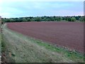
Ploughed Field
This field is just north of the A419 which is marked by the band of trees running across the end of the field. The field boundary on the left is the minor road to Sapperton.
Image: © Nigel Mykura
Taken: 7 Oct 2011
0.17 miles
6
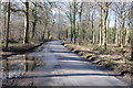
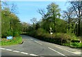
Road near Hailey Lodge
Country road through woodland near Hailey Lodge approaching the A419.
Image: © Philip Halling
Taken: 1 Mar 2014
0.17 miles
7
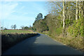
Road towards Sapperton
Branching off the A419.
Image: © Robin Webster
Taken: 9 Jan 2022
0.25 miles