
IMAGES TAKEN NEAR TO
Cirencester Office Park, Tetbury Road, CIRENCESTER, GL7 6JJ
Introduction
This page details the photographs taken nearby to Cirencester Office Park, Tetbury Road, GL7 6JJ by members of the Geograph project.
The Geograph project started in 2005 with the aim of publishing, organising and preserving representative images for every square kilometre of Great Britain, Ireland and the Isle of Man.

There are currently over 7.5m images from over14,400 individuals and you can help contribute to the project by visiting https://www.geograph.org.uk
Image Map
Images are licensed for reuse under creativecommons.org/licenses/by-sa/2.0
Notes
- Clicking on the map will re-center to the selected point.
- The higher the marker number, the further away the image location is from the centre of the postcode.
Image Listing (23 Images Found)
Images are licensed for reuse under creativecommons.org/licenses/by-sa/2.0
Image
Details
Distance
3
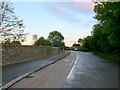
Old A419
This shows the quiet road with bicycle lane running along the wall belonging to Cirencester College. This used to be the A419 but this now passes further to the south where there is a large roundabout and this just leads to one of the college entrances.
Image: © Nigel Mykura
Taken: 7 Oct 2011
0.12 miles
5
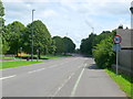
Chesterton Lane
This road runs from the A419 Tetbury Rd which is behind the photographer, east across the south side of the centre of the town.
Image: © Nigel Mykura
Taken: 17 Jun 2012
0.13 miles
6
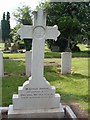
Gravestone belonging to W Leslie Savage
2nd Lieutenant Royal Flying Corps. Died June 16th 1917. This grave is located at Cirencester Cemetery, Chesterton Lane, Cirencester, Gloucestershire.
Image: © Paul Best
Taken: 8 Jun 2013
0.13 miles
7
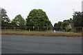
Bristol Road, Cirencester
Looking towards Chesterton Lane
Image: © David Howard
Taken: 23 May 2020
0.13 miles
8
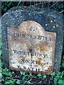
Milestone on The Fosse Way (Tetbury Road)
Image: © Anthony Parkes
Taken: 6 Apr 2014
0.14 miles
9
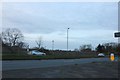
The A419, Cirencester
At the end of Chesterton Lane
Image: © David Howard
Taken: 23 Mar 2019
0.14 miles
10
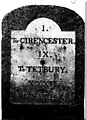
Old Milestone by the A429, Tetbury Road, Chesterton, Cirencester
Metal plate attached to stone post by the A429, in parish of CIRENCESTER (COTSWOLD District), 22yds from back entrance to Agricultural College, by the road, on North side of road. Cirencester Roman iron plate, erected by the Cirencester & Bath turnpike trust in the 19th century. For a newer photo see: Image
Inscription reads:-
I,
To CIRENCESTER.
IX,
To TETBURY.
XXXII,
To BATH.
Grade II listed.
List Entry Number: 1187416 https://historicengland.org.uk/listing/the-list/list-entry/1187416
Milestone Society National ID: GL_CIBA01.
Image: © JM Weightmann
Taken: 1 Jan 2000
0.14 miles