IMAGES TAKEN NEAR TO
Washpool Lane, CIRENCESTER, GL7 6FY
Introduction
This page details the photographs taken nearby to Washpool Lane, GL7 6FY by members of the Geograph project.
The Geograph project started in 2005 with the aim of publishing, organising and preserving representative images for every square kilometre of Great Britain, Ireland and the Isle of Man.

There are currently over 7.5m images from over14,400 individuals and you can help contribute to the project by visiting https://www.geograph.org.uk
Image Map
Images are licensed for reuse under creativecommons.org/licenses/by-sa/2.0
Notes
- Clicking on the map will re-center to the selected point.
- The higher the marker number, the further away the image location is from the centre of the postcode.
Image Listing (63 Images Found)
Images are licensed for reuse under creativecommons.org/licenses/by-sa/2.0
Image
Details
Distance
1
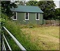
Side view of the former Methodist Church, Kemble
From a Washpool Lane field gate.
Image: © Jaggery
Taken: 14 Jun 2015
0.02 miles
2
Former Methodist Church, Kemble
In mid June 2015, the Washpool Lane corrugated metal building, formerly a Methodist Church, looks much improved from when I was last here in March 2012 http://www.geograph.org.uk/photo/2857070 which suggests that the building may now be in residential use, or perhaps a hall. There is no name on the building.
Image: © Jaggery
Taken: 14 Jun 2015
0.02 miles
3
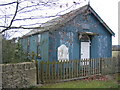
Kemble Methodist Church
A corrugated iron structure in advanced state of dilapidation.
Image: © Peter Watkins
Taken: 5 Mar 2006
0.02 miles
4
Former Methodist Church, Kemble
The abandoned corrugated metal building is on Washpool Lane.
Since this view http://www.geograph.org.uk/photo/132538 six years earlier, the name sign has been removed.
Image: © Jaggery
Taken: 18 Mar 2012
0.02 miles
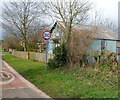
5
End of 30mph speed limit at eastern edge of Kemble
A view east along Washpool Lane as it heads out of Kemble. The 30mph speed limit in the village increases to the National Speed Limit.
On the left is the derelict former Methodist Church. http://www.geograph.org.uk/photo/2857070
Image: © Jaggery
Taken: 18 Mar 2012
0.02 miles
6
Start of the 30 zone at the eastern edge of Kemble
The National Speed Limit along Washpool Lane drops to 30mph alongside the former Methodist Church. http://www.geograph.org.uk/photo/4527816
Image: © Jaggery
Taken: 14 Jun 2015
0.02 miles
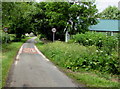
7
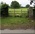
Washpool Lane stile to a public footpath, Kemble
The notice on the right states that access over the footpath is to be on foot only and is by permission of the landowner. Pursuant to Section 31 of the Highways Act 1980 this is not a highway or public footpath. Please remain on the footpath at all times and keep all dogs on a lead.
Image: © Jaggery
Taken: 14 Jun 2015
0.02 miles
8
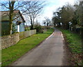
Washpool Lane, Kemble
Looking towards School Road.
Image: © Jaggery
Taken: 14 Jun 2015
0.03 miles
9
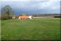
Field on the north side of Washpool Lane near Kemble
A view north from near the eastern edge of the derelict former Methodist Church. http://www.geograph.org.uk/photo/2857070
After a bright morning with much blue sky, ominously dark grey clouds appeared briefly to the north. Fortunately no rain fell on this walker today.
Image: © Jaggery
Taken: 18 Mar 2012
0.05 miles
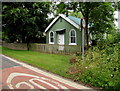
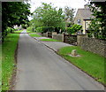
10
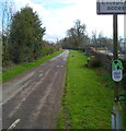
Kemble : Washpool Lane is a Quiet Lane
A quiet lane is part of a network of rural roads in Gloucestershire where minimal traffic calming measures are used to enable all road users to "share with care".
Image: © Jaggery
Taken: 18 Mar 2012
0.07 miles