IMAGES TAKEN NEAR TO
CIRENCESTER, GL7 5YD
Introduction
This page details the photographs taken nearby to GL7 5YD by members of the Geograph project.
The Geograph project started in 2005 with the aim of publishing, organising and preserving representative images for every square kilometre of Great Britain, Ireland and the Isle of Man.

There are currently over 7.5m images from over14,400 individuals and you can help contribute to the project by visiting https://www.geograph.org.uk
Image Map
Images are licensed for reuse under creativecommons.org/licenses/by-sa/2.0
Notes
- Clicking on the map will re-center to the selected point.
- The higher the marker number, the further away the image location is from the centre of the postcode.
Image Listing (17 Images Found)
Images are licensed for reuse under creativecommons.org/licenses/by-sa/2.0
Image
Details
Distance
1
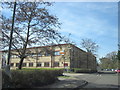
Cirencester Delivery Office
Cirencester Delivery Office delivers to everywhere with a GL7 postcode.
Image: © Roy Hughes
Taken: 25 Mar 2017
0.01 miles
2
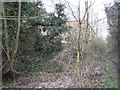
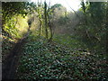
Remains of the Cirencester branch of the Thames & Severn Canal
Just visible in the undergrowth is the bed of the branch of the canal from Siddington to the terminal basin in Cirencester. Beyond this point to the Image the canal has been infilled and built over. One the more recent buildings erected on the canal line can be seen through the trees. Behind the photographer towards Siddington the course of the canal is clearly visible, although infilled in places. The route of the towpath remains as a public footpath however.
Image: © David Stowell
Taken: 12 Mar 2009
0.05 miles
3

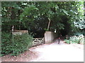
Path coming out on Love Lane
Path coming out on Love Lane industrial estate
Image: © Shaun Ferguson
Taken: 11 Feb 2012
0.08 miles
4
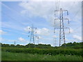
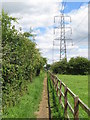
Power Lines near Upper Siddington
These powerlines feed into a substation on the southern edge of Cirencester. Just beyond the first pair of pylons is a dismantled railway line.
Image: © Nigel Mykura
Taken: 17 Jun 2012
0.11 miles
5
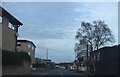
Wilkinson Road on the Cirencester Industrial Estate
Image: © David Howard
Taken: 23 Mar 2019
0.12 miles
6
Thames and Severn Canal, Cirencester Arm
This is part of what remains of the Cirencester arm of the Thames and Severn Canal. It ran from the junction above Siddington Upper Lock to Cirencester Wharf, which was somewhere near Waitrose. The Thames and Severn Way officially follows it only part of the way, the part in the photograph being merely a public footpath.
http://www.pikelock.co.uk/canal/t&scanal/cirencester%20arm/cirencester%20arm.html http://www.cotswoldcanals.com/pages/locks-bridges-structures/bridges-and-buildings.php https://en.wikipedia.org/wiki/Thames_and_Severn_Canal
Image: © Vieve Forward
Taken: 29 Dec 2015
0.13 miles
7
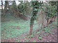
Public footpath at Siddington
A public footpath at Siddington, near Cirencester.
Image: © Malc McDonald
Taken: 11 Jul 2020
0.15 miles
8
Public footpath near Cirencester
A public footpath on the outskirts of Cirencester in Gloucestershire.
Image: © Malc McDonald
Taken: 11 Jul 2020
0.16 miles
9
Thames & Severn Canal - Cirencester Branch
Whilst much of the branch has been filled in, along this length the channel is still clearly visible from the public footpath along the old towpath.
Image: © David Stowell
Taken: 12 Mar 2009
0.17 miles
10
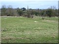
View towards Siddington
Looking east from the towpath of the former Cirencester Branch of the Thames & Severn Canal. The line of trees across the middle of the picture mark the line of the former Midland & South Western Junction Railway from Cirencester (Watermoor) to Swindon (Old Town). The church spire in the distance is that of Image
Image: © David Stowell
Taken: 12 Mar 2009
0.17 miles