IMAGES TAKEN NEAR TO
Ablington, CIRENCESTER, GL7 5NZ
Introduction
This page details the photographs taken nearby to Ablington, GL7 5NZ by members of the Geograph project.
The Geograph project started in 2005 with the aim of publishing, organising and preserving representative images for every square kilometre of Great Britain, Ireland and the Isle of Man.

There are currently over 7.5m images from over14,400 individuals and you can help contribute to the project by visiting https://www.geograph.org.uk
Image Map
Images are licensed for reuse under creativecommons.org/licenses/by-sa/2.0
Notes
- Clicking on the map will re-center to the selected point.
- The higher the marker number, the further away the image location is from the centre of the postcode.
Image Listing (36 Images Found)
Images are licensed for reuse under creativecommons.org/licenses/by-sa/2.0
Image
Details
Distance
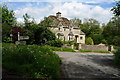
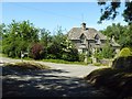
2
Corner houses, Ablington
Cotswold stone.
Image: © Robin Webster
Taken: 25 Mar 2017
0.01 miles
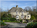
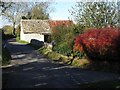
5
Road junction near Ablington
Country road junction with a fine cottage in the background near Ablington.
Image: © Philip Halling
Taken: 17 Jun 2017
0.02 miles
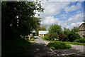
6
Road junction & barn, southwest side of Ablington
Image: © Colin Park
Taken: 27 Oct 2012
0.02 miles
7
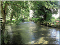
River Coln upstream of Ablington Bridge
This charming little river rises at Brockhampton to the east of Cheltenham, and flows in a south/south-easterly direction through the Cotswold Hills. It joins the River Thames to the south-west of Lechlade.
Image: © Stuart Logan
Taken: 13 Sep 2012
0.05 miles
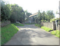
8
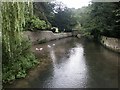
Looking downstream on the Coln, Ablington
From the road bridge in the village.
Image: © Katy Walters
Taken: 15 Aug 2006
0.06 miles
9
![Ablington houses [1]](https://s1.geograph.org.uk/geophotos/07/50/22/7502217_56aa5a1d_120x120.jpg)
Ablington houses [1]
Bridge House was formerly two houses, now one. Built in the mid or late 18th century with 20th century rear alterations. Constructed of limestone rubble stone with ashlar chimneys under a stone slate roof. Listed, grade II, with details at: https://historicengland.org.uk/listing/the-list/list-entry/1341831
The hamlet of Ablington is located in Gloucestershire astride the River Coln some 6¼ miles northeast of Cirencester and about 1 mile upstream from Bibury. The name 'Ablington' is derived from the 'estate called after Eadbald' (personal name Ēadbald + ing + tūn) and has been recorded as Eadbaldingtun, Ablinton and Ablyngton.
Image: © Michael Dibb
Taken: 10 May 2023
0.06 miles
10
![Ablington houses [5]](https://s1.geograph.org.uk/geophotos/07/50/22/7502253_ac1a46d1_120x120.jpg)
Ablington houses [5]
The boundary wall and gate piers to Ablington Manor are 18th century, restored in the early 20th century. Constructed of limestone rubble stone with ashlar piers and dressed coping. (See also Image) Listed, grade II, with details at: https://historicengland.org.uk/listing/the-list/list-entry/1088391
The hamlet of Ablington is located in Gloucestershire astride the River Coln some 6¼ miles northeast of Cirencester and about 1 mile upstream from Bibury. The name 'Ablington' is derived from the 'estate called after Eadbald' (personal name Ēadbald + ing + tūn) and has been recorded as Eadbaldingtun, Ablinton and Ablyngton.
Image: © Michael Dibb
Taken: 10 May 2023
0.07 miles