IMAGES TAKEN NEAR TO
Arlington Pike, CIRENCESTER, GL7 5DN
Introduction
This page details the photographs taken nearby to Arlington Pike, GL7 5DN by members of the Geograph project.
The Geograph project started in 2005 with the aim of publishing, organising and preserving representative images for every square kilometre of Great Britain, Ireland and the Isle of Man.

There are currently over 7.5m images from over14,400 individuals and you can help contribute to the project by visiting https://www.geograph.org.uk
Image Map
Images are licensed for reuse under creativecommons.org/licenses/by-sa/2.0
Notes
- Clicking on the map will re-center to the selected point.
- The higher the marker number, the further away the image location is from the centre of the postcode.
Image Listing (12 Images Found)
Images are licensed for reuse under creativecommons.org/licenses/by-sa/2.0
Image
Details
Distance
1
Stone Stile, Bibury
On Pudding Hill Farm along the Gloucestershire footpath KBY18 looking NW. The view looking SE is Image
Image: © Mr Red
Taken: 3 Jan 2022
0.02 miles
2
Stone Stile, Bibury
On Pudding Hill Farm along the Gloucestershire footpath KBY18 looking SE. The view looking NW is Image
Image: © Mr Red
Taken: 3 Jan 2022
0.02 miles
3
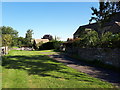
Public footpath passing Arlington Farm
Image: © Vieve Forward
Taken: 31 Jul 2020
0.16 miles
4
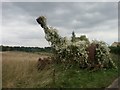
Overgrown farm machinery, Arlington, near Bibury
A rusting precursor to the mechanised combine harvester, now languishing under Russian Vine.
Image: © Katy Walters
Taken: 15 Aug 2006
0.16 miles
5
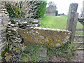
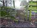
Stone Stile, Bibury
In the area known as Arlington Corner, on the Gloucestershire footpath KBY18 looking SE. The view NW is Image The route has labels naming it "The Palladian Way (an Architectural trail)"
Image: © Mr Red
Taken: 3 Jan 2022
0.16 miles
6
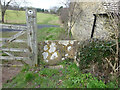
Stone Stile, Bibury
In the area known as Arlington Corner, on the Gloucestershire footpath KBY18 looking NW to fields. The view SE is Image The route has labels naming it "The Palladian Way (an Architectural trail)"
Image: © Mr Red
Taken: 3 Jan 2022
0.16 miles
7
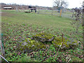
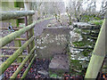
Stone Stile, Bibury
Fallen idles. The one in the foreground is about 1m from the current route of Gloucestershire footpath KBY18 and a wooden stile. The pile due North near the horse are similarly close to a farm track. At least one of these groups was probably the remains of a stone stile. An old farm house called Upper Severalls is to the NW, Ablington further NNW. The field beyond the hedges is the site of Rowberrow Camp, a series of ditches surrounding several small tumps.
Image: © Mr Red
Taken: 3 Jan 2022
0.20 miles
8
![Bibury houses [2]](https://s2.geograph.org.uk/geophotos/07/50/33/7503370_8b8ac14e_120x120.jpg)
Bibury houses [2]
Arlington Farmhouse was built in the mid to late 17th century and enlarged circa 1800. Constructed of coursed limestone rubble stone under a stone slate roof. There is a rear wing. Listed, grade II, with details at: https://historicengland.org.uk/listing/the-list/list-entry/1341837
Bibury was described by William Morris (1834-96) as "the most beautiful village in England". Located in Gloucestershire, astride the River Coln, it is some 6½ miles northeast of Cirencester and about 26 miles west of Oxford. In the Domesday Book of 1086, the village is named Becheberie. Now a major tourist destination.
Image: © Michael Dibb
Taken: 10 May 2023
0.21 miles
9
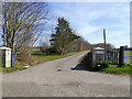
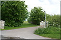
Private road to Pudding Hill
The name is carved on the left post, on the right is a council sign advising of private property and that the path should be stuck to. This is in parallel with the road at first but on the right side of the hedge.
Image: © Robin Webster
Taken: 25 Mar 2017
0.21 miles