IMAGES TAKEN NEAR TO
Kempsford, FAIRFORD, GL7 4EH
Introduction
This page details the photographs taken nearby to GL7 4EH by members of the Geograph project.
The Geograph project started in 2005 with the aim of publishing, organising and preserving representative images for every square kilometre of Great Britain, Ireland and the Isle of Man.

There are currently over 7.5m images from over14,400 individuals and you can help contribute to the project by visiting https://www.geograph.org.uk
Image Map
Images are licensed for reuse under creativecommons.org/licenses/by-sa/2.0
Notes
- Clicking on the map will re-center to the selected point.
- The higher the marker number, the further away the image location is from the centre of the postcode.
Image Listing (7 Images Found)
Images are licensed for reuse under creativecommons.org/licenses/by-sa/2.0
Image
Details
Distance
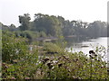
3
Gravel and Teasels by the Lake
An old gravel pit has been redeveloped for housing and recreation. Some of the spacious new premises can be seen on the far side.
On this side a bare gravel bank has been left, perhaps as a fishing platform?
Image: © Des Blenkinsopp
Taken: 8 Mar 2022
0.18 miles
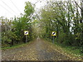
4
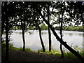
Lake seen through the trees
In the Whelford Pools Nature Reserve.
Image: © andrew auger
Taken: 27 Jun 2010
0.18 miles
5
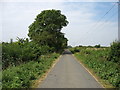
The lane to Whelford
Behind the camera, this lane is a cul-de-sac leading only to the River Coln and Dudgrove Farm.
Image: © David Purchase
Taken: 18 Aug 2016
0.19 miles
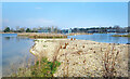
7
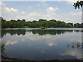
Whelford Pools
One of the lakes in the Whelford Pools Nature Reserve.Bought by the Gloucestershire trust for Nature Conservation in 1979, formed as a result of gravel extraction during the 1960s.
Image: © andrew auger
Taken: 27 Jun 2010
0.25 miles