IMAGES TAKEN NEAR TO
Totterdown Lane, FAIRFORD, GL7 4DG
Introduction
This page details the photographs taken nearby to Totterdown Lane, GL7 4DG by members of the Geograph project.
The Geograph project started in 2005 with the aim of publishing, organising and preserving representative images for every square kilometre of Great Britain, Ireland and the Isle of Man.

There are currently over 7.5m images from over14,400 individuals and you can help contribute to the project by visiting https://www.geograph.org.uk
Image Map
Images are licensed for reuse under creativecommons.org/licenses/by-sa/2.0
Notes
- Clicking on the map will re-center to the selected point.
- The higher the marker number, the further away the image location is from the centre of the postcode.
Image Listing (2 Images Found)
Images are licensed for reuse under creativecommons.org/licenses/by-sa/2.0
Image
Details
Distance
1
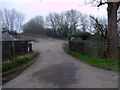
Entrance to track to Totterdown Farm, Totterdown Lane
The entrance to the track to Totterdown Lane gives nothing away about its destination. Past the pile of rock salt on the left and the tumbled-down building on the right, it seems to peter out, but the notice reading "Private Road Not a Public Footpath" belies the fact that something might lie at the end of the track.
Image: © Vieve Forward
Taken: 15 Mar 2012
0.15 miles
2
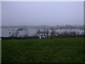
Gravel pit, Totterdown Lane, Horcott
This gravel pit appears as dry land on the most recent maps. It looks as if it may have been recently flooded, as there are plenty of trees and bushes poking up through the water. This was taken close to the very end of a restricted byway (which the owners of the houses had marked "Private" some distance earlier), and being little frequented, was teeming with wildlife.
Image: © Vieve Forward
Taken: 15 Mar 2012
0.18 miles