IMAGES TAKEN NEAR TO
Longdoles Bank, LECHLADE, GL7 3GB
Introduction
This page details the photographs taken nearby to Longdoles Bank, GL7 3GB by members of the Geograph project.
The Geograph project started in 2005 with the aim of publishing, organising and preserving representative images for every square kilometre of Great Britain, Ireland and the Isle of Man.

There are currently over 7.5m images from over14,400 individuals and you can help contribute to the project by visiting https://www.geograph.org.uk
Image Map
Images are licensed for reuse under creativecommons.org/licenses/by-sa/2.0
Notes
- Clicking on the map will re-center to the selected point.
- The higher the marker number, the further away the image location is from the centre of the postcode.
Image Listing (8 Images Found)
Images are licensed for reuse under creativecommons.org/licenses/by-sa/2.0
Image
Details
Distance
1
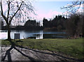
Claydon Coarse Fishery, near Lechlade
Claydon Park Fishery is a forty-year-old 4 ½ acre mature lake. The lake holds coarse fish including carp and pike to over 30lb, tench and bream to over 10lb, and roach and perch to over 3lb. Day tickets can be purchased.
Image: © Vieve Forward
Taken: 15 Feb 2012
0.17 miles
2
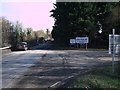
Entrance to gravel pits
The gravel extraction around Lechlade and Fairford over the years has resulted in many flooded lakes which now comprise the Cotswold Water Park. This scene is north of the river Coln, one of the headstreams of the Thames, and is well into Gloucestershire, not Swindon.
Image: © Jonathan Billinger
Taken: 3 Jan 2007
0.20 miles
3
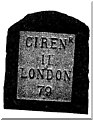
Old Milestone by the A417, Lechlade Parish
Metal plate attached to stone post by the A417, in parish of LECHLADE (COTSWOLD District), just East of entrance to Claydon Fields, by the road, on South side of road. Cirencester iron plate, erected by the Cirencester to St John's Bridge turnpike trust in the 19th century.
For a more recent image see Image
Inscription reads:-
CIRENR
11
LONDON
79
Milestone Society National ID: GL_LG79.
Image: © JM Weightmann
Taken: 1 Dec 1999
0.21 miles
4
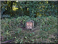
Old Milestone, A417
Metal plate attached to stone post by the A417, in parish of LECHLADE (COTSWOLD District), just East of entrance to Claydon Fields, by the road, on South side of road. Cirencester iron plate, erected by the Cirencester to St John's Bridge turnpike trust in the 19th century.
Inscription reads: CIRENᴿ / 11 / LONDON / 79
Milestone Society National ID: GL_LG79
Image: © Mr Red
Taken: 9 Oct 2021
0.22 miles
5
Entrance to Hanson Claydon Pike Works and Coln Country Park
This is the entrance both to Hanson Aggregates Claydon Pike Works and to Coln Country Park. The gravel pit to the right of this entrance has been flooded to form Coln Park Lake, which is home to Bowmoor Sailing Club. Coln Country Park is part of the Cotswold Water Park Fairford/Lechlade Section. To the south of the lake, gravel is being extracted by Hanson Aggregates Ltd.
Image: © Vieve Forward
Taken: 15 Feb 2012
0.22 miles
6
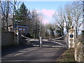
Entrance to The Lakes private estate
The Lakes is an exclusive private estate of luxury homes set in 650 acres of Cotswold countryside. The architect-designed houses cost over £870,000 and there is strict security at the main entrance.
Image: © Vieve Forward
Taken: 15 Feb 2012
0.23 miles
7
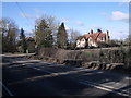
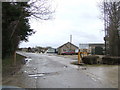
House on corner of lane to Claydon Fields
Image: © Vieve Forward
Taken: 15 Feb 2012
0.24 miles
8
![A figure of eight walk from Lechlade-on-Thames [33]](https://s3.geograph.org.uk/geophotos/07/26/52/7265227_b7252e14_120x120.jpg)
A figure of eight walk from Lechlade-on-Thames [33]
Here the access road, also a public footpath, is known as Bowmoor Reach.
After leaving Lechlade, the route joins the long distance Thames and Severn Way and passes the southern edge of Bowmoor Lake. Turning north, and looping around the northern edge of the lake, the Thames and Severn Way is re-joined and followed to the banks of the River Thames and back to Lechlade. Slightly over 5 miles.
Image: © Michael Dibb
Taken: 8 Jun 2022
0.24 miles