IMAGES TAKEN NEAR TO
St. Johns Priory, LECHLADE, GL7 3EZ
Introduction
This page details the photographs taken nearby to St. Johns Priory, GL7 3EZ by members of the Geograph project.
The Geograph project started in 2005 with the aim of publishing, organising and preserving representative images for every square kilometre of Great Britain, Ireland and the Isle of Man.

There are currently over 7.5m images from over14,400 individuals and you can help contribute to the project by visiting https://www.geograph.org.uk
Image Map
Images are licensed for reuse under creativecommons.org/licenses/by-sa/2.0
Notes
- Clicking on the map will re-center to the selected point.
- The higher the marker number, the further away the image location is from the centre of the postcode.
Image Listing (191 Images Found)
Images are licensed for reuse under creativecommons.org/licenses/by-sa/2.0
Image
Details
Distance
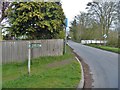
5
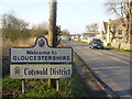
Welcome to Gloucestershire
County sign, and District sign, on the A417 Lechlade Road just north of St John's Bridge over the Thames. This is close to a tripoint where Gloucestershire, Oxfordshire and Wiltshire meet.
Image: © Colin Smith
Taken: 19 Mar 2011
0.04 miles
6
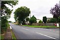
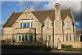
A417 road, Lechlade-on-Thames, Glos
The A417 road is here heading for the town centre and then goes to Fairford and Cirencester. On the right an unclassified road goes east and passes near the village of Kelmscott. On the corner is St.John's Priory Park, a park homes development for people aged over fifty.
Image: © P L Chadwick
Taken: 4 Sep 2016
0.07 miles
7
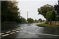
The A417 approaching Lechlade
Taken looking towards Lechlade from the junction with the road from Kelmscott. The Gloucestershire county signs can be seen beside the road.
Image: © andrew auger
Taken: 11 Oct 2009
0.07 miles
8
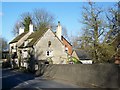
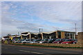
The Trout Inn, Lechlade on Thames
The Trout stands beside the A417 not far from St John's Bridge over the River Thames.
Image: © Maigheach-gheal
Taken: 30 Jan 2010
0.08 miles
9
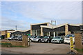
Alternative route
The sign says that this is the alternative route of the Thames Path. Until recently this was the route of the path which now runs alongside the river a little south of this position.
Image: © Michael Dibb
Taken: 3 Apr 2019
0.08 miles
10
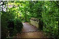
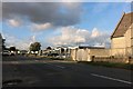
Footbridge at the end of Church Path causeway, Lechlade-on-Thames, Glos
The causeway, part of Church Path, carries a public footpath which runs from the town centre to the A417 road, near the Trout Inn. The footbridge crosses a drain, one of the many watercourses in this area.
Image: © P L Chadwick
Taken: 4 Sep 2016
0.08 miles