IMAGES TAKEN NEAR TO
Gloucester Road, CIRENCESTER, GL7 2JY
Introduction
This page details the photographs taken nearby to Gloucester Road, GL7 2JY by members of the Geograph project.
The Geograph project started in 2005 with the aim of publishing, organising and preserving representative images for every square kilometre of Great Britain, Ireland and the Isle of Man.

There are currently over 7.5m images from over14,400 individuals and you can help contribute to the project by visiting https://www.geograph.org.uk
Image Map
Images are licensed for reuse under creativecommons.org/licenses/by-sa/2.0
Notes
- Clicking on the map will re-center to the selected point.
- The higher the marker number, the further away the image location is from the centre of the postcode.
Image Listing (27 Images Found)
Images are licensed for reuse under creativecommons.org/licenses/by-sa/2.0
Image
Details
Distance
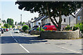
1
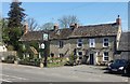
Drillmans Arms, Stratton
A traditional, good old fashioned pub just outside of Cirencester.
Image: © Helen Iwanczuk
Taken: 18 Apr 2018
0.02 miles
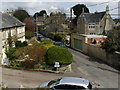
2
![A walk through Cirencester Park and Stratton [31]](https://s2.geograph.org.uk/geophotos/06/84/55/6845590_00e5af82_120x120.jpg)
A walk through Cirencester Park and Stratton [31]
Donside has become a public footpath heading towards Gloucester Road.
The village of Stratton was once a separate parish. It is now part of Cirencester, the centre of which lies about one mile south.
Cirencester, the largest town in the Cotswolds, is a market town some 15 miles south east of Gloucester and some 13 miles north west of Swindon. The town lies on the River Churn, a tributary of the River Thames and is the hub of a network of roads. It is the home of the Royal Agricultural University, founded in 1840. An important Roman settlement known as Corinium, the town, with 240 acres enclosed by walls was second only to London in size.
Image: © Michael Dibb
Taken: 12 May 2021
0.08 miles
3
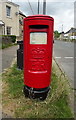
Elizabeth II postbox on Cheltenham Road, Stratton
Outside the Post Office.
Postbox No. GL7 45.
See Image] for context.
Image: © JThomas
Taken: 11 Jul 2019
0.08 miles
4
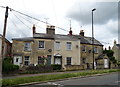
Cottages on Cheltenham Road (A435), Stratton
Image: © JThomas
Taken: 11 Jul 2019
0.09 miles
5
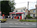
Post Office and shop on Cheltenham Road, Stratton
Showing position of Postbox No. GL7 45.
See Image] for postbox.
Image: © JThomas
Taken: 11 Jul 2019
0.09 miles
6
![Stratton houses [1]](https://s3.geograph.org.uk/geophotos/07/00/02/7000235_5243c22b_120x120.jpg)
Stratton houses [1]
Syrena House, number 1 Cheltenham Road, is dated 1835 with later alterations and additions. Constructed of red brick under a Welsh slate roof. Some original internal fittings remain. Listed, grade II, with details at: https://historicengland.org.uk/listing/the-list/list-entry/1187437
The village of Stratton was once a separate parish. It is now part of Cirencester, the centre of which lies about one mile south. Cirencester, the largest town in the Cotswolds, is a market town some 15 miles south east of Gloucester and some 13 miles north west of Swindon. The town lies on the River Churn, a tributary of the River Thames and is the hub of a network of roads. It is the home of the Royal Agricultural University, founded in 1840. An important Roman settlement known as Corinium, the town, with 240 acres enclosed by walls was second only to London in size.
Image: © Michael Dibb
Taken: 15 Jun 2021
0.09 miles
7
Cheltenham Road, Stratton
As the name indicates, Stratton, effectively a suburb of Cirencester with a population of about 2,500, is situated on a Roman road, in this case Ermin Way that linked Gloucester with Silchester (not to be confused with Ermine Street). The road in this view was not part of the Roman road but is now the A435 leading through the Cotswold countryside to Cheltenham.
Image: © Stephen McKay
Taken: 29 Jul 2022
0.10 miles
8
Albion St
View up Albion Street from upper side windows of Number 41, centrally showing main part of the street and, to the left, the small side turning known as 'the Private Road'. This used to be a side entrance into the grounds of Stratton House until the mid 2000's when the Stratton House owners had it blocked by a wall. Albion Street is one of the oldest streets in Stratton and quite a lot of the houses were originally occupied by servants of the family at Stratton House.
Image: © Bob Irving
Taken: 27 Apr 2013
0.10 miles
9
![Stratton features [1]](https://s3.geograph.org.uk/geophotos/07/00/02/7000239_708dddb0_120x120.jpg)
Stratton features [1]
A K6 telephone box, designed in 1935 by Sir Giles Gilbert Scott. There is a closer view at Image Listed, grade II, with details at: https://historicengland.org.uk/listing/the-list/list-entry/1187438
The village of Stratton was once a separate parish. It is now part of Cirencester, the centre of which lies about one mile south. Cirencester, the largest town in the Cotswolds, is a market town some 15 miles south east of Gloucester and some 13 miles north west of Swindon. The town lies on the River Churn, a tributary of the River Thames and is the hub of a network of roads. It is the home of the Royal Agricultural University, founded in 1840. An important Roman settlement known as Corinium, the town, with 240 acres enclosed by walls was second only to London in size.
Image: © Michael Dibb
Taken: 15 Jun 2021
0.11 miles
10
![Stratton features [2]](https://s1.geograph.org.uk/geophotos/07/00/02/7000241_317843b6_120x120.jpg)
Stratton features [2]
A K6 telephone box, designed in 1935 by Sir Giles Gilbert Scott. The box is seen in context at Image Listed, grade II, with details at: https://historicengland.org.uk/listing/the-list/list-entry/1187438
The village of Stratton was once a separate parish. It is now part of Cirencester, the centre of which lies about one mile south. Cirencester, the largest town in the Cotswolds, is a market town some 15 miles south east of Gloucester and some 13 miles north west of Swindon. The town lies on the River Churn, a tributary of the River Thames and is the hub of a network of roads. It is the home of the Royal Agricultural University, founded in 1840. An important Roman settlement known as Corinium, the town, with 240 acres enclosed by walls was second only to London in size.
Image: © Michael Dibb
Taken: 15 Jun 2021
0.11 miles