IMAGES TAKEN NEAR TO
Thomas Street, CIRENCESTER, GL7 2AX
Introduction
This page details the photographs taken nearby to Thomas Street, GL7 2AX by members of the Geograph project.
The Geograph project started in 2005 with the aim of publishing, organising and preserving representative images for every square kilometre of Great Britain, Ireland and the Isle of Man.

There are currently over 7.5m images from over14,400 individuals and you can help contribute to the project by visiting https://www.geograph.org.uk
Image Map
Images are licensed for reuse under creativecommons.org/licenses/by-sa/2.0
Notes
- Clicking on the map will re-center to the selected point.
- The higher the marker number, the further away the image location is from the centre of the postcode.
Image Listing (996 Images Found)
Images are licensed for reuse under creativecommons.org/licenses/by-sa/2.0
Image
Details
Distance
1
![Cirencester buildings [65]](https://s2.geograph.org.uk/geophotos/06/86/15/6861578_683ff84f_120x120.jpg)
Cirencester buildings [65]
Number 8A Thomas Street (seen here) and number 8 Thomas Street (Image) are two houses now used as offices. Built during the 18th century in coursed squared limestone (number 8) and coursed rubble stone (number 8A) both with a stone slate roof. Listed, grade II, with details at: https://historicengland.org.uk/listing/the-list/list-entry/1206681
Cirencester, the largest town in the Cotswolds, is a market town some 15 miles southeast of Gloucester and some 13 miles northwest of Swindon. The town lies on the River Churn, a tributary of the River Thames, and is the hub of a network of roads. It is the home of the Royal Agricultural University, founded in 1840. An important Roman settlement known as Corinium, the town, with 240 acres enclosed by walls, was second only to London in size.
Image: © Michael Dibb
Taken: 12 May 2021
0.01 miles
2
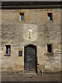
Weavers Hall; St. Thomas's Hospital
On Thomas Street,the oldest secular building in the town, and continuously occupied since the 15th century.
Image: © Peter Barr
Taken: 4 May 2013
0.01 miles
3
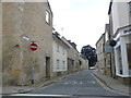
Thomas Street
This is one of the old streets close to the centre of the town. The old houses are nearly all built of Cotswold stone, some of them ashlar and some rubble
Image: © Nigel Mykura
Taken: 8 Jul 2012
0.01 miles
4
![Cirencester buildings [64]](https://s1.geograph.org.uk/geophotos/06/86/15/6861577_6d9513e8_120x120.jpg)
Cirencester buildings [64]
Number 8 Thomas Street (seen here) and number 8A Thomas Street (Image) are two houses now used as offices. Built during the 18th century in coursed squared limestone (number 8) and coursed rubble stone (number 8A) both with a stone slate roof. Listed, grade II, with details at: https://historicengland.org.uk/listing/the-list/list-entry/1206681
Cirencester, the largest town in the Cotswolds, is a market town some 15 miles south east of Gloucester and some 13 miles north west of Swindon. The town lies on the River Churn, a tributary of the River Thames and is the hub of a network of roads. It is the home of the Royal Agricultural University, founded in 1840. An important Roman settlement known as Corinium, the town, with 240 acres enclosed by walls was second only to London in size.
Image: © Michael Dibb
Taken: 12 May 2021
0.01 miles
5
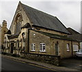
Salvation Army hall, Thomas Street, Cirencester
Home of the Cirencester Corps of The Salvation Army, located almost opposite the Friends Meeting House. http://www.geograph.org.uk/photo/4825048
Image: © Jaggery
Taken: 10 Feb 2016
0.01 miles
6
![Cirencester buildings [66]](https://s2.geograph.org.uk/geophotos/06/86/15/6861582_f6a7630c_120x120.jpg)
Cirencester buildings [66]
The Salvation Army Temperance Hall, number 10 Thomas Street, has an attached schoolroom to the rear. Built in 1846, on the site of an earlier brewery, it was the first temperance hall in the west of England. In the Gothic style, the hall is constructed of coursed, squared limestone with ashlar dressings and roofed partly with stone slate and partly artificial stone slate. Listed, grade II, with details at: https://historicengland.org.uk/listing/the-list/list-entry/1206711
Cirencester, the largest town in the Cotswolds, is a market town some 15 miles south east of Gloucester and some 13 miles north west of Swindon. The town lies on the River Churn, a tributary of the River Thames and is the hub of a network of roads. It is the home of the Royal Agricultural University, founded in 1840. An important Roman settlement known as Corinium, the town, with 240 acres enclosed by walls was second only to London in size.
Image: © Michael Dibb
Taken: 12 May 2021
0.01 miles
7
![Cirencester buildings [67]](https://s1.geograph.org.uk/geophotos/06/86/15/6861585_a00650f5_120x120.jpg)
Cirencester buildings [67]
A plaque on the Temperance Hal seen at Image
Cirencester, the largest town in the Cotswolds, is a market town some 15 miles south east of Gloucester and some 13 miles north west of Swindon. The town lies on the River Churn, a tributary of the River Thames and is the hub of a network of roads. It is the home of the Royal Agricultural University, founded in 1840. An important Roman settlement known as Corinium, the town, with 240 acres enclosed by walls was second only to London in size.
Image: © Michael Dibb
Taken: 12 May 2021
0.01 miles
8
![Cirencester houses [80]](https://s1.geograph.org.uk/geophotos/06/86/27/6862725_820b85c3_120x120.jpg)
Cirencester houses [80]
Number 17 Thomas Street was built in the 18th century and was altered in the 19th century. Constructed of coursed, square rubble stone with a concrete tile roof. There are rear extensions of the 19th century and the 20th century. Listed, grade II, with details at: https://historicengland.org.uk/listing/the-list/list-entry/1206684
Cirencester, the largest town in the Cotswolds, is a market town some 15 miles south east of Gloucester and some 13 miles north west of Swindon. The town lies on the River Churn, a tributary of the River Thames and is the hub of a network of roads. It is the home of the Royal Agricultural University, founded in 1840. An important Roman settlement known as Corinium, the town, with 240 acres enclosed by walls was second only to London in size.
Image: © Michael Dibb
Taken: 12 May 2021
0.02 miles
9
![Cirencester houses [82]](https://s2.geograph.org.uk/geophotos/06/86/27/6862742_30e2f8f9_120x120.jpg)
Cirencester houses [82]
Number 29 Thomas Street is a mid to late 17th century house. Built of coursed rubble stone with a concrete tile roof. There are a number of exposed timber lintels. Listed, grade II, with details at: https://historicengland.org.uk/listing/the-list/list-entry/1206701
Cirencester, the largest town in the Cotswolds, is a market town some 15 miles south east of Gloucester and some 13 miles north west of Swindon. The town lies on the River Churn, a tributary of the River Thames and is the hub of a network of roads. It is the home of the Royal Agricultural University, founded in 1840. An important Roman settlement known as Corinium, the town, with 240 acres enclosed by walls was second only to London in size.
Image: © Michael Dibb
Taken: 12 May 2021
0.02 miles
10
![Cirencester houses [83]](https://s2.geograph.org.uk/geophotos/06/86/27/6862746_a99eb9f4_120x120.jpg)
Cirencester houses [83]
Number 49 Thomas Street is an early 19th century house, altered later in the same century and probably incorporating an earlier building. Built on a double pile plan, of coursed, squared limestone under a Welsh slate roof. Listed, grade II, with details at: https://historicengland.org.uk/listing/the-list/list-entry/1187530
Cirencester, the largest town in the Cotswolds, is a market town some 15 miles south east of Gloucester and some 13 miles north west of Swindon. The town lies on the River Churn, a tributary of the River Thames and is the hub of a network of roads. It is the home of the Royal Agricultural University, founded in 1840. An important Roman settlement known as Corinium, the town, with 240 acres enclosed by walls was second only to London in size.
Image: © Michael Dibb
Taken: 12 May 2021
0.02 miles