Cirencester buildings [66]
Introduction
The photograph on this page of Cirencester buildings [66] by Michael Dibb as part of the Geograph project.
The Geograph project started in 2005 with the aim of publishing, organising and preserving representative images for every square kilometre of Great Britain, Ireland and the Isle of Man.

There are currently over 7.5m images from over 14,400 individuals and you can help contribute to the project by visiting https://www.geograph.org.uk
Cirencester buildings [66]
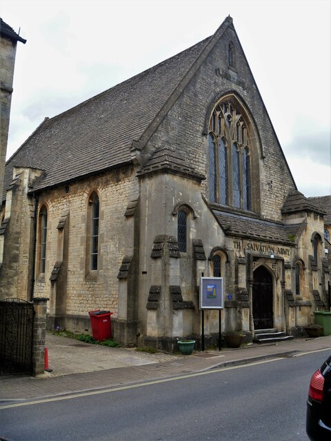
Image: © Michael Dibb Taken: 12 May 2021
The Salvation Army Temperance Hall, number 10 Thomas Street, has an attached schoolroom to the rear. Built in 1846, on the site of an earlier brewery, it was the first temperance hall in the west of England. In the Gothic style, the hall is constructed of coursed, squared limestone with ashlar dressings and roofed partly with stone slate and partly artificial stone slate. Listed, grade II, with details at: https://historicengland.org.uk/listing/the-list/list-entry/1206711 Cirencester, the largest town in the Cotswolds, is a market town some 15 miles south east of Gloucester and some 13 miles north west of Swindon. The town lies on the River Churn, a tributary of the River Thames and is the hub of a network of roads. It is the home of the Royal Agricultural University, founded in 1840. An important Roman settlement known as Corinium, the town, with 240 acres enclosed by walls was second only to London in size.
Images are licensed for reuse under creativecommons.org/licenses/by-sa/2.0
Image Location
Latitude
51.719062
Longitude
-1.971435