IMAGES TAKEN NEAR TO
Gardner Way, CIRENCESTER, GL7 1ZA
Introduction
This page details the photographs taken nearby to Gardner Way, GL7 1ZA by members of the Geograph project.
The Geograph project started in 2005 with the aim of publishing, organising and preserving representative images for every square kilometre of Great Britain, Ireland and the Isle of Man.

There are currently over 7.5m images from over14,400 individuals and you can help contribute to the project by visiting https://www.geograph.org.uk
Image Map
Images are licensed for reuse under creativecommons.org/licenses/by-sa/2.0
Notes
- Clicking on the map will re-center to the selected point.
- The higher the marker number, the further away the image location is from the centre of the postcode.
Image Listing (29 Images Found)
Images are licensed for reuse under creativecommons.org/licenses/by-sa/2.0
Image
Details
Distance
1
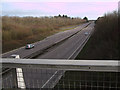
Intersection of A429 Burford Road and A417(T) looking south
View to the south from the bridge carrying the A429 Burford Road over the A417(T) dual carriageway.
Image: © Vieve Forward
Taken: 22 Jan 2012
0.07 miles
2
A419 approaching Burford Road junction
Image: © Julian P Guffogg
Taken: 7 Aug 2013
0.07 miles
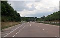
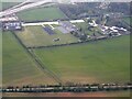
4
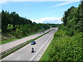
The A419 Cirencester bypass
A view to the north-west of the A419 towards its junction with the A429.
Image: © Philip Halling
Taken: 10 Oct 2022
0.13 miles
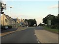
5
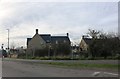
New David Wilson Homes in Cirencester
It appears there is a local window tax in Cirencester going by the size of them.
Image: © David Howard
Taken: 23 Mar 2019
0.14 miles
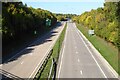
6
A419 Cirencester Bypass
The western grid line of the square follows very closely the line of the old Fosse Way just here. The blue car is located approximately where the Roman road used to run across the middle of the image. The Fosse Way at this point was obliterated when this new dual carriageway was built as the town's bypass. The bridge in the distance, the A429, now carries the Fosse Way traffic across the new road.
Image: © Nigel Mykura
Taken: 17 Jun 2012
0.14 miles
7
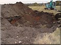
Clearing The Edwardian Dump In Cirencester
Looking from the field next to Burford Road towards Arnolds Way Cirencester
Image: © Paul Best
Taken: 28 Oct 2003
0.17 miles
8
London Road Cirencester
The edge of town as at early 2006. London Road is the A417 which meanders off towards Reading
Image: © Peter Watkins
Taken: 1 Apr 2006
0.17 miles
9
Chinook helicopter heading to South Cerney Airfield
View from an air balloon - Chinook Helicopter heading to South Cerney Airfield.
Image: © Peter Randall-Cook
Taken: 29 Sep 2003
0.18 miles
10

Pasture Field near Cirencester
The trees hide a large road junction where the A429 intersects with the A419 just north east of the town. This field is in a triangle formed by these two roads and the old Fosse Way.
Image: © Nigel Mykura
Taken: 17 Jun 2012
0.19 miles