IMAGES TAKEN NEAR TO
London Road, CIRENCESTER, GL7 1AB
Introduction
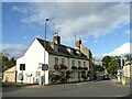
This page details the photographs taken nearby to London Road, GL7 1AB by members of the Geograph project.
The Geograph project started in 2005 with the aim of publishing, organising and preserving representative images for every square kilometre of Great Britain, Ireland and the Isle of Man.

There are currently over 7.5m images from over14,400 individuals and you can help contribute to the project by visiting https://www.geograph.org.uk
Image Map
Images are licensed for reuse under creativecommons.org/licenses/by-sa/2.0
Notes
- Clicking on the map will re-center to the selected point.
- The higher the marker number, the further away the image location is from the centre of the postcode.
Image Listing (250 Images Found)
Images are licensed for reuse under creativecommons.org/licenses/by-sa/2.0
Image
Details
Distance
1
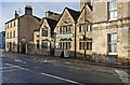
The Old Brewhouse
A 17th century town house run as a bed & breakfast establishment.
Image: © Rod Allday
Taken: 19 Aug 2021
0.01 miles
2

The Old Brewhouse, 5-7 London Road, Cirencester, Glos
The building is believed to date from the 17th century and is now used as a bed and breakfast establishment. Presumably, at some point, it was used as a brewery or maybe a public house that brewed its own beer, as many did a hundred or more years ago.
Image: © P L Chadwick
Taken: 22 Dec 2013
0.01 miles
3
Waggon and Horses Inn Cirencester
Waggon and Horses Inn Cirencester
Research links
http://pubshistory.com/Gloucestershire/Cirencester/index.shtml
http://www.gloucestershirepubs.co.uk/FeatureFiller/index.php
Image: © Paul Best
Taken: 28 Mar 2013
0.02 miles
4
![Cirencester buildings [30]](https://s1.geograph.org.uk/geophotos/06/37/47/6374773_d0f51fa1_120x120.jpg)
Cirencester buildings [30]
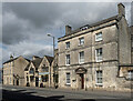
The Waggon and Horses Inn was built in the 17th century and totally rebuilt in 1920 in the Cotswold vernacular style, similar to the original. Closed since January, 2018 permission has recently (September, 2019) been granted to convert the property into flats.
Cirencester, the largest town in the Cotswolds, is a market town some 15 miles south east of Gloucester and some 13 miles north west of Swindon. The town lies on the River Churn, a tributary of the River Thames and is the hub of a network of roads. It is the home of the Royal Agricultural University, founded in 1840. An important Roman settlement known as Corinium, the town, with 240 acres enclosed by walls was second only to London in size.
Image: © Michael Dibb
Taken: 24 Sep 2019
0.02 miles
5
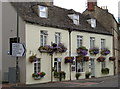
The Old Brewhouse
Located on what was a fairly busy junction even before the post-war expansion of the roads, the Old Brewhouse was once the Nag's Head Inn. Now a B&B it announces its presence with some attractive hanging baskets.
Image: © Neil Owen
Taken: 18 Aug 2014
0.02 miles
6
![Cirencester houses [13]](https://s2.geograph.org.uk/geophotos/06/37/47/6374774_0163cb6f_120x120.jpg)
Cirencester houses [13]
The Old Brewhouse at numbers 5 to 7 London Road is 17th century and now offers bed and breakfast accommodation.
Cirencester, the largest town in the Cotswolds, is a market town some 15 miles south east of Gloucester and some 13 miles north west of Swindon. The town lies on the River Churn, a tributary of the River Thames and is the hub of a network of roads. It is the home of the Royal Agricultural University, founded in 1840. An important Roman settlement known as Corinium, the town, with 240 acres enclosed by walls was second only to London in size.
Image: © Michael Dibb
Taken: 24 Sep 2019
0.02 miles
7
The Waggon & Horses (1), 11 London Road, Cirencester, Glos
Originally an 18th century coaching inn, the Waggon & Horses is sometimes referred to as the Waggon & Horses Inn. It does indeed function much as a traditional inn, having a bar, a restaurant and offering bed and breakfast. Unusually the chefs are Thai, so both Asian and English cuisine is available. The bar has cask ales. The building is Grade II listed.
Image
Image: © P L Chadwick
Taken: 22 Dec 2013
0.02 miles
8
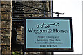
The Waggon & Horses (2) - sign, 11 London Road, Cirencester, Glos
This used to be a coaching inn when it opened in the 18th century. In those days goods were carried all over the country by waggon and horses, as there were no railways. Many inns acted as agents and goods could be left there for despatch or for collection by local people. This may be the origin of this particular establishment's name.
Image
Image: © P L Chadwick
Taken: 22 Dec 2013
0.02 miles
9
![Cirencester houses [11]](https://s1.geograph.org.uk/geophotos/06/37/47/6374769_82d8b74d_120x120.jpg)
Cirencester houses [11]
Oxford House is early/mid 19th century probably incorporating an earlier building. The house has been converted into flats and is part of a large late 20th century housing development. Edward VIII when Prince of Wales is said to have kept a flat in the house for when he came to Cirencester to play polo. Listed, grade II, with details at: https://historicengland.org.uk/listing/the-list/list-entry/1298685
Cirencester, the largest town in the Cotswolds, is a market town some 15 miles south east of Gloucester and some 13 miles north west of Swindon. The town lies on the River Churn, a tributary of the River Thames and is the hub of a network of roads. It is the home of the Royal Agricultural University, founded in 1840. An important Roman settlement known as Corinium, the town, with 240 acres enclosed by walls was second only to London in size.
Image: © Michael Dibb
Taken: 24 Sep 2019
0.02 miles
10
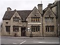
11-15 London Road, Cirencester
Three-storey Oxford House is early C19th and has a pedimented doorcase (Image]). Grade II listed.
Next door is the Waggon and Horses pub (Image]), a 1920 rebuild in the style of the original C17th alehouse. The pub closed in 2018 and, like countless other pubs across the country, has since been converted to flats.
Image: © Stephen Richards
Taken: 16 Aug 2015
0.02 miles