IMAGES TAKEN NEAR TO
Frithwood Close, STROUD, GL6 8RA
Introduction
This page details the photographs taken nearby to Frithwood Close, GL6 8RA by members of the Geograph project.
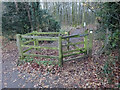
The Geograph project started in 2005 with the aim of publishing, organising and preserving representative images for every square kilometre of Great Britain, Ireland and the Isle of Man.

There are currently over 7.5m images from over14,400 individuals and you can help contribute to the project by visiting https://www.geograph.org.uk
Image Map
Images are licensed for reuse under creativecommons.org/licenses/by-sa/2.0
Notes
- Clicking on the map will re-center to the selected point.
- The higher the marker number, the further away the image location is from the centre of the postcode.
Image Listing (12 Images Found)
Images are licensed for reuse under creativecommons.org/licenses/by-sa/2.0
Image
Details
Distance
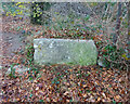
1
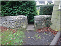
Stone Stile, Frith Cemetery
Frith cemetery, the Frith, opposite Frith Wood, looking South. The view looking out is Image
Image: © Mr Red
Taken: 16 Dec 2021
0.06 miles
2
Stone Stile, Frith Cemetery
Frith cemetery, the Frith, opposite Frith Wood, looking NE outwards. The view looking in is Image
Image: © Mr Red
Taken: 16 Dec 2021
0.06 miles
3
The Frith, Bussage
Frith Wood to the right.
Image: © Jonathan Billinger
Taken: 11 Feb 2016
0.06 miles
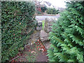
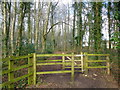
4
Stone Stile, Chalford
SE entrance to Frith Wood, on The Frith Looking NE, the view North after ivy removal is Image
Image: © James Clarke
Taken: 25 Aug 2020
0.07 miles
5
Stone Stile, Chalford
SE entrance to Frith Wood, on The Frith, after removing the ivy. The longer shot of this looking NE is Image
Image: © Mr Red
Taken: 16 Dec 2021
0.07 miles
6
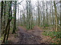
Frith Wood, 1
A public space almost completely surrounded by the housing estates of Bussage and Chalford.
Image: © Jonathan Billinger
Taken: 11 Feb 2016
0.08 miles
7
Frith Wood, 2
A public space almost completely surrounded by the housing estates of Bussage and Chalford.
Image: © Jonathan Billinger
Taken: 11 Feb 2016
0.09 miles
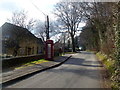
8
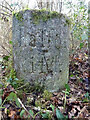
Modern Waymarker, Chalford
A palimpsest placed here by a local resident, Donald Workman, about 5 years ago. Inscribed by him. At the junction of Gloucestershire footpaths MCH20 and MCH19 near the Frith and Frith Wood. Donald can be heard talking about the area in olden days at this http://stroudvoices.co.uk/find/#donald_workman
Inscription: Chalford / 1 M
Milestone Society National ID: GL_CHA01
Image: © Mr Red
Taken: 17 Feb 2022
0.11 miles
9
Stile, Frith Wood
In the NE corner of Frith Wood. This as a stone stile prior to 1979 when the houses behind the camera where built. It was dug up by the developers and an enterprising 28-year-old saved it from the breakers' yard. Afterwards, he told the old guys in the pub and one reported "That was where I did my courting!". It is used as a seat in its saviour's garden to this day. See current location Image
Image: © Mr Red
Taken: 16 Dec 2021
0.17 miles
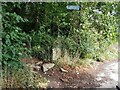
10
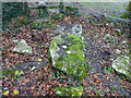
Stone Stile, Brownshill
Fallen remains of a slab type stone stile, adjacent to a wooden stile. Looking in the direction of the wooden stile. The view looking South is Image
Image: © Mr Red
Taken: 16 Dec 2021
0.20 miles