IMAGES TAKEN NEAR TO
St. Marys, STROUD, GL6 8QB
Introduction
This page details the photographs taken nearby to St. Marys, GL6 8QB by members of the Geograph project.
The Geograph project started in 2005 with the aim of publishing, organising and preserving representative images for every square kilometre of Great Britain, Ireland and the Isle of Man.

There are currently over 7.5m images from over14,400 individuals and you can help contribute to the project by visiting https://www.geograph.org.uk
Image Map
Images are licensed for reuse under creativecommons.org/licenses/by-sa/2.0
Notes
- Clicking on the map will re-center to the selected point.
- The higher the marker number, the further away the image location is from the centre of the postcode.
Image Listing (51 Images Found)
Images are licensed for reuse under creativecommons.org/licenses/by-sa/2.0
Image
Details
Distance
1
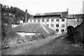
St Mary's Mill, Chalford
The Stroud valley area was full of assorted textile mills and many still survive in various states.
Image: © Chris Allen
Taken: 9 Mar 1985
0.01 miles
2
St Mary's Mill, Chalford
Latterly used for walking stick manufacture.
Home to a preserved water wheel and stationary steam engine.
Image: © Chris Allen
Taken: 9 Mar 1985
0.01 miles
3
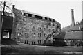
St Mary's Mill, Chalford
Former walking stick manufactory. Home to a steam engine and a water wheel. Open to the public very occasionally.
Image: © Chris Allen
Taken: 12 May 2001
0.01 miles
4
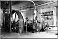
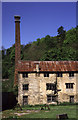
Steam engine, St Mary's Mill
Very atmospheric engine house with a Tangye side by side compound steam engine. The rod exiting to the right operates the air pump in a combined jet condenser and air pump assembly. Open occasionally.
Image: © Chris Allen
Taken: 27 Sep 1981
0.03 miles
5
![Houses above the A419 [London Road]](https://s1.geograph.org.uk/geophotos/04/89/46/4894697_22534402_120x120.jpg)
Houses above the A419 [London Road]
In the steep-side valley of the River Frome.
Image: © Christine Johnstone
Taken: 28 Mar 2016
0.03 miles
6
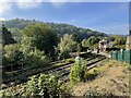
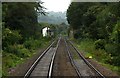
St. Mary's Crossing railway Halt (site), Gloucestershire
Opened in 1903 by the Great Western Railway on the line from Swindon to Gloucester, this station closed in 1964.
View west towards Brimscombe and Gloucester. The two, short, parallel platforms were on this side of the level crossing. A footbridge was also formerly present at this site. Only the signal box was still extant when this image was taken.
Image: © Nigel Thompson
Taken: 9 Oct 2021
0.04 miles
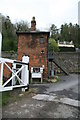
7
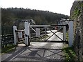
Brimscombe St Mary's level crossing, from the north
On a narrow and steep lane between the A419 and a mill converted to housing. Staffed, and controlled by locked gates, which can only be opened with an interlocking Annett key.
Image: © Christine Johnstone
Taken: 28 Mar 2016
0.04 miles
8
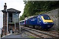
St Mary's Crossing
Paddington bound HST passes the signal box at St Mary's Crossing.
Image: © Stuart Wilding
Taken: 15 Sep 2012
0.04 miles
9
Level crossing - Brimscombe St Mary's
This is a very rare GWR style manned level crossing with an interlock device that only releases the brass keys to open the gates when there isn't a train coming. The two keys are held in devices in the open white box at the foot of the keeper's cabin.
Image: © Chris Allen
Taken: 28 Apr 2012
0.05 miles