IMAGES TAKEN NEAR TO
Chalford Industrial Estate, STROUD, GL6 8NT
Introduction
This page details the photographs taken nearby to Chalford Industrial Estate, GL6 8NT by members of the Geograph project.
The Geograph project started in 2005 with the aim of publishing, organising and preserving representative images for every square kilometre of Great Britain, Ireland and the Isle of Man.

There are currently over 7.5m images from over14,400 individuals and you can help contribute to the project by visiting https://www.geograph.org.uk
Image Map
Images are licensed for reuse under creativecommons.org/licenses/by-sa/2.0
Notes
- Clicking on the map will re-center to the selected point.
- The higher the marker number, the further away the image location is from the centre of the postcode.
Image Listing (58 Images Found)
Images are licensed for reuse under creativecommons.org/licenses/by-sa/2.0
Image
Details
Distance
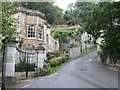
1
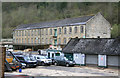
Bliss Mill, Chalford
This is an old mill site and has variously been used for fulling, woollen cloth manufacture and walking stick manufacture. The site closed around 1930 and the surviving buildings are now the nucleus of a small trading estate.
Image: © Chris Allen
Taken: 28 Apr 2012
0.00 miles
2
Bliss Mill, Chalford
This is an old mill site and has variously been used for fulling, woollen cloth manufacture and walking stick manufacture. The site closed around 1930 and the surviving buildings are now the nucleus of a small trading estate.
Image: © Chris Allen
Taken: 28 Apr 2012
0.05 miles
3
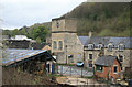
Bliss Mill, Chalford Industrial Estate
This is an old mill site and has variously been used for fulling, woollen cloth manufacture and walking stick manufacture. The site closed around 1930 and the surviving buildings are now the nucleus of a small trading estate.
Image: © Chris Allen
Taken: 28 Apr 2012
0.05 miles
4
Bliss Mill, Chalford Industrial Estate
This is an old mill site and has variously been used for fulling, woollen cloth manufacture and walking stick manufacture. The site closed around 1930 and the surviving buildings are now the nucleus of a small trading estate.
Image: © Chris Allen
Taken: 28 Apr 2012
0.05 miles
5
Dark Lane, Golden Valley
Dark Lane climbs the steep slopes of Chalford Hill from the A419 in Chalford Bottom.
Image: © Nigel Mykura
Taken: 7 Oct 2011
0.07 miles
6
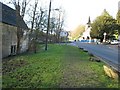
Route of Thames & Severn Canal through Chalford
The Thames & Severn Canal and the main Stroud - Cirencester Road run side by side approaching Chalford. While the canal was abandoned some road widening and re-alignment has taken place over the canal. In 1967 the road here was widened and the remainder of the canal is currently buried under the grass verge.
Image: © David Stowell
Taken: 30 Jan 2008
0.08 miles
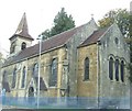
7
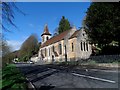
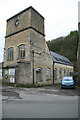
Christ Church, Chalford
Built in 1725, enlarged in 1841 with further alterations in 1890. See http://www.britishlistedbuildings.co.uk/en-132860-church-of-christ-church-with-railings-ch
Image: © Bikeboy
Taken: 8 Apr 2014
0.09 miles
8
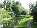
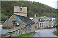
The Thames and Severn Canal, at Chalford
Looking upstream, at this point the canal went through a short tunnel. The tower of Christ Church is seen on the left.
Image: © David Purchase
Taken: 21 Jun 2017
0.10 miles
10
Chalford Round House
Built for lengthsmen on the Thames And Severn Canal, and used as a Toll House for the Minchinhampton, Tetbury and Bisley Turnpike Trust, at some stage in its life.
Milestone Society National ID: GL.CHA02
Image: © Mr Red
Taken: 22 Apr 2022
0.10 miles