IMAGES TAKEN NEAR TO
Far Oakridge, STROUD, GL6 7PG
Introduction
This page details the photographs taken nearby to GL6 7PG by members of the Geograph project.
The Geograph project started in 2005 with the aim of publishing, organising and preserving representative images for every square kilometre of Great Britain, Ireland and the Isle of Man.

There are currently over 7.5m images from over14,400 individuals and you can help contribute to the project by visiting https://www.geograph.org.uk
Image Map
Images are licensed for reuse under creativecommons.org/licenses/by-sa/2.0
Notes
- Clicking on the map will re-center to the selected point.
- The higher the marker number, the further away the image location is from the centre of the postcode.
Image Listing (4 Images Found)
Images are licensed for reuse under creativecommons.org/licenses/by-sa/2.0
Image
Details
Distance
1
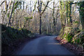
Lane towards Waterlane
From the Daneway direction, with Frith Wood on the left.
Image: © Robin Webster
Taken: 9 Jan 2022
0.04 miles
2
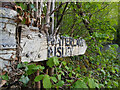
Fingerpost, Waterlane
Traditional fingerpost at the junction of Waterlane & the road to Oakridge. In the Tunley, Frith Wood and Holy Brook area.
Inscription: Waterlane / Bisley // Far Oakridge / Chalford
Milestone Society ID: GL_SO9204
Image: © James Clarke
Taken: 19 Jun 2021
0.08 miles
3
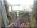
Stone Stile, Far Oakridge
Off the road going NE from Far Oakridge between 'The Frith' & 'Frith House' on Gloucestershire footpath MBL108. Looking SE from the road, the view NW towards the road is Image
Image: © Mr Red
Taken: 24 Feb 2022
0.22 miles
4
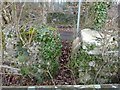
Stone Stile, Far Oakridge
Off the road going NE from Far Oakridge between 'The Frith' & 'Frith House' on Gloucestershire footpath MBL108. Looking NW from the field, the view NW from the road is Image
Image: © Mr Red
Taken: 24 Feb 2022
0.22 miles