1
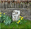
"Stone", Bisley Rd, Bisley
In front of the boundary wall to modern houses. At ½ mile from Bisley on the ancient route from Cirencester to Gloucester, this might have served as a way marker at some stage. It is mid point 'twixt http://www.geograph.org.uk/photo/6098094 (Bisley) & https://www.geograph.org.uk/photo/6072984 (Catswood Lane) and 1 mile from the "stone" in Limekiln Lane - http://www.geograph.org.uk/photo/6668880 .
Milestone Society National ID: GL_CIBI10
Image: © Mr Red
Taken: 18 Mar 2019
0.02 miles
2
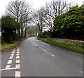
Minor road from Bisley towards Stroud
The 30mph speed limit increases to 40mph.
Image: © Jaggery
Taken: 30 Dec 2018
0.14 miles
3
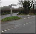
Calf Way north of Bisley
North of the junction on the left, Cheltenham Road behind the camera becomes Calf Way ahead.
Pointing ahead, a sign near the camera shows two miles to The Camp, five miles to Birdlip.
Image: © Jaggery
Taken: 30 Dec 2018
0.15 miles
4
Direction and distances sign on a grass triangle north of Bisley
Two miles from The Camp and five miles from Birdlip,
the black arrow on the sign points along Calf Way. https://www.geograph.org.uk/photo/6011492
Image: © Jaggery
Taken: 30 Dec 2018
0.16 miles
5
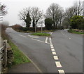
Y-junction north of Bisley
Viewed from the northwest end of Cheltenham Road.
Left for a minor road towards Stroud.
Right along Calf Way for The Camp (2 miles) and Birdlip (5).
Image: © Jaggery
Taken: 30 Dec 2018
0.16 miles
6
Give Way sign and hydrant marker on a grass triangle, Bisley
Facing the minor road from Stroud. Calf Way is on the left.
Cheltenham Road on the right leads to the centre of Bisley.
Image: © Jaggery
Taken: 30 Dec 2018
0.16 miles
7
Cheltenham Road houses near the corner of Windyridge, Bisley
Cheltenham Road houses are on the right. Windyridge https://www.geograph.org.uk/photo/6011448 houses are on the left.
Image: © Jaggery
Taken: 30 Dec 2018
0.17 miles
8
Windyridge, Bisley
The northeast end of the cul-de-sac Windyridge viewed across Cheltenham Road.
Image: © Jaggery
Taken: 30 Dec 2018
0.18 miles
9
Windyridge, Bisley
Image: © Alex McGregor
Taken: 10 Sep 2012
0.19 miles
10
Junction in the north of Bisley
Windyridge from the right joins Cheltenham Road.
Image: © Jaggery
Taken: 30 Dec 2018
0.19 miles


