IMAGES TAKEN NEAR TO
Lypiatt, STROUD, GL6 7LQ
Introduction
This page details the photographs taken nearby to GL6 7LQ by members of the Geograph project.
The Geograph project started in 2005 with the aim of publishing, organising and preserving representative images for every square kilometre of Great Britain, Ireland and the Isle of Man.

There are currently over 7.5m images from over14,400 individuals and you can help contribute to the project by visiting https://www.geograph.org.uk
Image Map
Images are licensed for reuse under creativecommons.org/licenses/by-sa/2.0
Notes
- Clicking on the map will re-center to the selected point.
- The higher the marker number, the further away the image location is from the centre of the postcode.
Image Listing (5 Images Found)
Images are licensed for reuse under creativecommons.org/licenses/by-sa/2.0
Image
Details
Distance
1
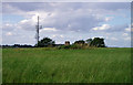
Trig point and radio mast above Stroud
Two structures taking advantage of the prominent ridge rising to the east of Stroud. The Bisley road, from which the photo was taken, also uses the ridge to gain the Cotswold plateau, where progress is easier than in the steep and narrow valleys
Image: © David Gruar
Taken: 30 Jul 2006
0.05 miles
2
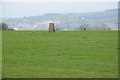
Trig point on Lypiatt Hill
Trig point on Lypiatt Hill viewed from the road near Lypiatt Hill Farm.
Image: © Philip Halling
Taken: 10 Mar 2012
0.05 miles
3
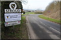
Stroud town sign
Sign on the Bisley road entering the town of Stroud. Note Stroud is the world's first bee guardian town.
Image: © Philip Halling
Taken: 10 Mar 2012
0.16 miles
4
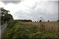
Wood and field
Wood and field off 40 Acres Lane
Image: © P Gaskell
Taken: Unknown
0.18 miles
5
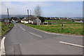
Bisley Road, Stroud
Bisley Road entering the edge of Stroud.
Image: © Philip Halling
Taken: 10 Mar 2012
0.24 miles