IMAGES TAKEN NEAR TO
Miserden, STROUD, GL6 7HZ
Introduction
This page details the photographs taken nearby to GL6 7HZ by members of the Geograph project.
The Geograph project started in 2005 with the aim of publishing, organising and preserving representative images for every square kilometre of Great Britain, Ireland and the Isle of Man.

There are currently over 7.5m images from over14,400 individuals and you can help contribute to the project by visiting https://www.geograph.org.uk
Image Map
Images are licensed for reuse under creativecommons.org/licenses/by-sa/2.0
Notes
- Clicking on the map will re-center to the selected point.
- The higher the marker number, the further away the image location is from the centre of the postcode.
Image Listing (4 Images Found)
Images are licensed for reuse under creativecommons.org/licenses/by-sa/2.0
Image
Details
Distance
1
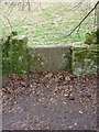
Stone stile nr Henley Farm Cottages, Miserden GS1053
Stone slab stile on footpath from the school to Henley Farm Cottages, Miserden. On public right of way MMN27 , stile where the path enters small wood below cottages
Image: © M Wills
Taken: 11 Mar 2021
0.09 miles
2
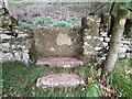
Stone stile nr Henley Farm Cottages, Miserden GS1053
Stone slab stile on footpath from the school to Henley Farm Cottages, Miserden. On public right of way MMN27 , stile where the path enters small wood below cottages
Image: © Susan Lang
Taken: 15 Sep 2020
0.10 miles
3
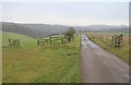
Road to Park Farm
As the waymark shows, footpath MMN/25/2 follows the drive towards the western branch of the wooded upper Frome valley past gates and fencing.
Image: © Derek Harper
Taken: 1 Jan 2011
0.18 miles
4
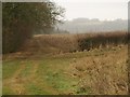
Fields near Henley Farm
A view towards the western branch of the upper Frome valley from footpath MMN/24/1. On the left is the edge of New Park Wood. A gloomy wet day.
Image: © Derek Harper
Taken: 1 Jan 2011
0.19 miles