IMAGES TAKEN NEAR TO
Tibbiwell Lane, STROUD, GL6 6YA
Introduction
This page details the photographs taken nearby to Tibbiwell Lane, GL6 6YA by members of the Geograph project.
The Geograph project started in 2005 with the aim of publishing, organising and preserving representative images for every square kilometre of Great Britain, Ireland and the Isle of Man.

There are currently over 7.5m images from over14,400 individuals and you can help contribute to the project by visiting https://www.geograph.org.uk
Image Map
Images are licensed for reuse under creativecommons.org/licenses/by-sa/2.0
Notes
- Clicking on the map will re-center to the selected point.
- The higher the marker number, the further away the image location is from the centre of the postcode.
Image Listing (265 Images Found)
Images are licensed for reuse under creativecommons.org/licenses/by-sa/2.0
Image
Details
Distance
1
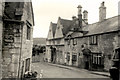
Painswick - Golden Heart Inn
Taken in the 1960's ??
Is that a Commer van on the right?
Image: © Clive Randall-Cook (Deceased)
Taken: Unknown
0.01 miles
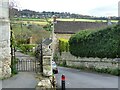
2
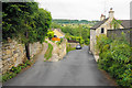
Tibbiwell Lane, Painswick
A lane leading down to the valley of Painswick Stream. There are some steep gradients on this side of the town.
Image: © Bill Boaden
Taken: 23 Jul 2015
0.04 miles
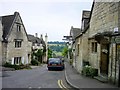
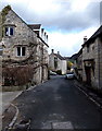
3
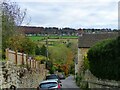
Looking down the hill, Tibbiwell Lane, Painswick
Image: © Ruth Sharville
Taken: 13 Nov 2021
0.05 miles
4
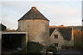
Drying stove - painswick
An iconic symbol of the Cotswold and Wiltshire woollen industry and lauded as one of the best examples.
Image: © Chris Allen
Taken: 30 Nov 2014
0.05 miles
5
Tibbiwell Lane, Painswick
One of the many narrow streets in this classic Cotswold village. See also Image
Image: © Ruth Sharville
Taken: 13 Nov 2021
0.06 miles
6
Tibbiwell Lane, Painswick
This road runs east and then SE down the hill to Brookhouse Mill.
Image: © Penny Mayes
Taken: 6 Jul 2003
0.06 miles
7
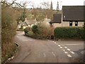
Tibbiwell Lane, Painswick
The junction, at the foot of a very steep hill, with Randalls Field (right). The lane then crosses into Image before the right bend. Tibbiwell is a corruption of (St) Tabitha's Well, part way up the hill.
Image: © Derek Harper
Taken: 2 Jan 2011
0.07 miles
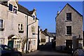
9
Vicarage Street, Painswick
Looking east, away from the town centre.
Image: © Jaggery
Taken: 23 Mar 2014
0.10 miles
10
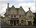
Painswick Bistro
One of many excellent Cotswold buildings in this heritage village.
http://www.cotswolds.info/places/painswick.shtml
Image: © Steve Fareham
Taken: 9 Dec 2008
0.10 miles