IMAGES TAKEN NEAR TO
Edge, STROUD, GL6 6NG
Introduction
This page details the photographs taken nearby to GL6 6NG by members of the Geograph project.
The Geograph project started in 2005 with the aim of publishing, organising and preserving representative images for every square kilometre of Great Britain, Ireland and the Isle of Man.

There are currently over 7.5m images from over14,400 individuals and you can help contribute to the project by visiting https://www.geograph.org.uk
Image Map
Images are licensed for reuse under creativecommons.org/licenses/by-sa/2.0
Notes
- Clicking on the map will re-center to the selected point.
- The higher the marker number, the further away the image location is from the centre of the postcode.
Image Listing (14 Images Found)
Images are licensed for reuse under creativecommons.org/licenses/by-sa/2.0
Image
Details
Distance
1
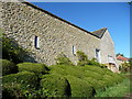
Barn conversion at Packhurst Farm
I think it's residential now.
Image: © Jeremy Bolwell
Taken: 6 Oct 2012
0.00 miles
2
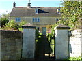
House at Packhurst Farm
A lovely approach to this property.
Image: © Jeremy Bolwell
Taken: 6 Oct 2012
0.01 miles
3
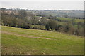
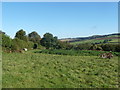
Farmland around Edge Farm
Farmland around Edge Farm in the valley between Edge and Painswick through which Wash Brook flows.
Image: © Philip Halling
Taken: 23 Feb 2013
0.07 miles
4
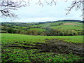
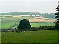
The Wash Brook valley
Typical Cotswolds countryside near Painswick.
Image: © Jonathan Billinger
Taken: 21 Dec 2011
0.14 miles
5
Rough pasture above Back Edge Farm
Some ancient farm machinery lies long abandoned here.
Image: © Jeremy Bolwell
Taken: 6 Oct 2012
0.16 miles
6
A view east from Sevenleaze Lane, Horsepools, Gloucestershire
The land descends from here to the Wash Brook and then rises again towards Painswick. The cattle and the hedge just behind them are in this square. The tree beyond is in the next square east.
Image: © Brian Robert Marshall
Taken: 30 Aug 2008
0.18 miles
7
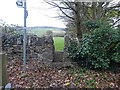
Stone Stile, Sevenleaze Lane
View from the road. The first step has a rivet Benchmark representing 190.0 m ASL. View from the field see Image The Benchmark was last surveyed in 1966 so this footpath and stile has existed for longer, but it is not clear that the route is only a "permissive path", the original registered route (Gloucestershire footpath MPA13) is not useable now.
Image: © Mr Red
Taken: 28 Nov 2021
0.23 miles
8
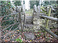
Stone Stile, Sevenleaze Lane
View from the field. Rivet Benchmark on the other side. Road view see Image The Benchmark was last surveyed in 1966 so this footpath and stile has existed for longer, but it is not clear that the route a only a "permissive path", the original registered route (Gloucestershire footpath MPA13) is not useable now.
Image: © Mr Red
Taken: 28 Nov 2021
0.23 miles
9
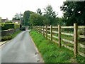
Sevenleaze Lane, Horsepools, Gloucestershire
The narrow lane leads from here to its junction with the A4173 main road into Stroud.
Image: © Brian Robert Marshall
Taken: 30 Aug 2008
0.23 miles
10
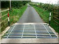
Sevenleaze Lane, Horsepools, Gloucestershire
The lane heads away north to some scattered properties west of Paradise. Horseriders can bypass the cattle grid via a gateway to the left, out of shot.
Image: © Brian Robert Marshall
Taken: 30 Aug 2008
0.24 miles